Black Butte Hike

17 08 2016

Of the many activities to choose from in Oregon’s Metolius River area, a hike up 6,436 ft Black Butte is one I had never undertaken. Black Butte (affectionately known as “Black Butt”) is a cinder cone, formed thousands of years ago when Central Oregon was much more geologically active. When in the area whether at Santiam Summit, Three Fingered Jack, the town of Sisters, the Metolius Valley, or McKenzie Pass, you can see cone-shaped Black Butte.

I had heard the hike is hard, but the 360-degree views are unsurpassed. So on my birthday weekend, we made plans to undertake it. Bill, Tatsuro and I took the challenge. It was a perfect bluebird day. Turns out much of the hike up is very exposed, so it’s a good thing we started in the morning.

There is a way to cut off most of the way up – because a road switchbacks up to a trailhead about halfway up the mountain. We arrived at 11 a.m., and it was almost filled with cars. Slathered in sunscreen and tanked up with water, we slung backpacks and started up. Lower portions are dotted with many old-growth, wind-blown Ponderosa Pines. It was clear to me that winter winds take their toll on trees clinging to the slopes.

20160612_115923

We were at Three Fingered Jack yesterday! Wow.

When we first emerged from the lower forest, we were rewarded with a view west – Three Fingered Jack! Yesterday’s clouds and fresh dust of snow were gone. But this was but one of many views we were to encounter on the two-plus mile to the summit. Just glimpsing this one added much energy to the quest. The hike is steep! Not for the timid. We met a lady at the trailhead who seemed really focused and let her go on. Little did we know, was doing the trail twice that day! Olympic training?

20160612_120733

Summit fire tower, with hikers below.

The hike is very steep and exposed to the sun and wind. On this day, we had sun and heat. But zero wind. It could have been much more hot. Or windy. We considered ourselves fortunate! And the views? Food for the hike. To the south – a view of geologic history. Newberry Crater, McKenzie Pass, and the Three Sisters!

20160612_120326

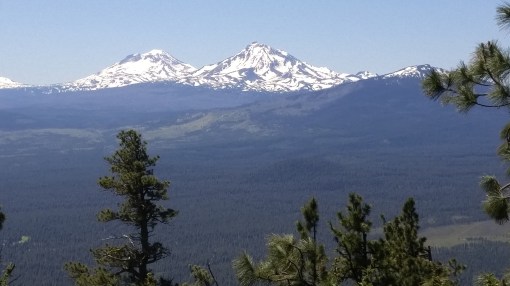
North and South Sister. Middle Sister is hidden.

Such beauty is breathtaking! Thousands of feet below us lay the Metolius River Valley and Black Butte Ranch.

But there was much more climbing to go. The trail finally switchbacks its way in a circuitous route eastward and then northward before it reaches the summit. Bonus! This means more views!

20160612_123936

10,450 ft Mt. Jefferson, Black Butte’s northern neighbor.

We enjoyed unlimited views in all directions along this hike, none more spectacular than that of Mt. Jefferson just to the north.

20160612_124715

Tatsuro, myself, and Bill. To the left are the Three Sisters, and on the right, Mt Washington.

Rod Trailhead

I love trails!

A 360 degree view is the treat when you summit Black Butte. You can also see all the way to 14,410 ft. Mt Rainier and 12,280 ft Mt Adams. Wow! We met many people there with lots of stories to tell. We then wolfed down our lunches, loaded up and made the journey home.

This was a birthday hike to remember! On the way down, I encountered the woman doing laps. All she could do was grunt. Well, I Hope to do many more hikes like this one!


Hike Up To Three Fingered Jack (Almost)

10 08 2016
20160611_120457

A brooding Three Fingered Jack awaits hikers

Our first Metolius River Region activity was to be a hike up to Three Fingered Jack. The trailhead is at Jack Lake, reached via a bony unmaintained dirt road. Myself, Bill, Tatsuro, David, Teresa and Anthony all did this hike.

The weather at the trailhead was warm. Yet the mountain remained shrouded in clouds most of the hike. When it did emerge, we saw fresh snow coating the rocky slopes.

20160611_105612

The first part of the trail was warm and sunny. Later, lots of blow down lay across. Bear grass blooming!

Years ago a massive forest fire scorched this region. Initially, the trail climbs through new growth which has sprung up since then. Bear grass, huckleberry, and young pines cover the landscape. The upper reaches were spared the conflagration. Up there, trail crews hadn’t gotten a chance to fix winter’s carnage, so a number of downed trees lay across the trail. We had to climb over or under.

20160611_130838

Wildflowers and new growth coming back, amongst the charred remains of the old forest.

20160611_115339

Snow patches several feet thick became more numerous as we got closer to Canyon Creek. Canyon Creek Meadows is a beautiful area which by July is a carpet of wildflowers. Once at Canyon Creek, the entire meadow was a threaded series of snowmelt streams, and it became difficult to continue. I decided to stop with David, Teresa and Anthony at a log, and have lunch. Bill and Teresa hiked further, but it wasn’t long before they returned. The trail got buried under snow and mud up there.


The Canyon Creek Meadows hike to Three Fingered Jack is a must-do if you visit the Metolius area. It’s only a few miles up to the foot of the mountain. Beautiful views and an up close look at an extinct volcano make it worth the hike!


Metolius River Birthday 2016

8 08 2016
20160611_090448

Right on cue, fly fishermen emerged as we set up our camp chairs.

Of Oregon’s many natural wonders, the Metolius River Valley stands out in my heart. With its red-bark Ponderosa Pines, dry air, fly fishermen and perfectly burbling river waters, the Metolius River valley is absolutely cinematic. I return there year after year, and have never been disappointed. I celebrated my birthday there this year with Bill, Tatsuro, plus my neighbors Teresa, Dave and son Anthony.

20160611_080455

Tatsuro’s riverside real estate! It warmed up so much we were down to T-shirts and shorts.

My favorite place to camp is the Allan Springs Campground. It sits on a peninsula in the river. Bill, Tatsuro and I left Portland early to score a campsite and we were rewarded with a big site on a bend in the river. We could see up the river, plus it meandered and bent just at our campsite. Once we set our chairs on the water’s edge, Tatsuro pronounced, “THIS is IT!” And he was right.

20160611_083252

Anthony found the hammock pretty quickly!


Maybe an hour after we set up, Dave, Teresa and Anthony joined us. There was a possible shower in the forecast so I set up my pop-up shelter over the picnic table. After happy hour by the river and chopping some wood for a fire, it was time to cook up some good grub!

Teresa Rod Bill at happy hour

Happy was the hour that day by the river

20160611_193415

Teresa does stir fry like a boss!

My favorite group camp meal by far is stir fry. Intimidating to the uninitiated, stir fry wins over everybody because what comes off the flame is fresh, hot, healthy and in no way can be screwed up. It’s so simple. Chop up the ingredients and leave them on the table in small tubs. Leave the sauces out. And let each camper have at it. The only drawback is it’s one wok meal at a time. Campers have to wait their turn, but it’s worth it. If someone offers to make something in advance, it only makes things worse as it sits getting cold. The one thing to make for everyone is rice. So, I bring a rice cooker and make it on a separate stove. No Jetboils here. They won’t work for a stir fry meal!

Supper finished and cleaned up. Time for relaxing by the fire. Well, that’s hard for Anthony, because there is wood to be chopped! I think he needed to burn some calories, which he surely did.

20160611_080226

Morning brings more guess what? FOOD. OMG. Talk about gluttony. Bacon, link and patty sausage. Eggs. Hash browns. Had enough? Oh no. Blueberry pancakes! Stuffed? There was more.

20160611_082157

Got to cook up all of it no matter what!

20160612_080113


Breakfast was birthday time! Pound cake with CoolWhip….OMG.

20160612_085248

A picture is worth 1,000 words!

OK. We did more than eat and drink. We hiked up to Three Fingered Jack, and also hiked to the summit of Black Butte – just two of the many things to do in the area. But those will be up coming blog posts! Stay tuned.


Hiking Amongst Siouxon Creek’s Emerald Waters and Waterfalls

6 05 2016

siouxon creek

Siouxon Creek trail is one of the most beautiful places to hike near Vancouver, Washington. Located in a deep valley, it rarely gets hot even during summer heat waves. April, Tatsuro, Monica and I spent a perfect afternoon hiking there last weekend.

Monica Tatsuro Rod

Monica, Tatsuro and myself.

Hiking Siouxon Creek leads you past flumes, towering moss-covered firs and maples, clear green pools and ends with a 45-foot waterfall. It’s about 4.3 miles to the waterfall, making for a full 8+ mile day. The trail continues past the waterfall. And you can connect with a trail leading to Huffman Peak, which would make for 14 miles total.

20160430_121317_HDR

There are perhaps ten backpacking campsites along this stretch. And on our hike it seemed most filled up. It would be a Lord of the Rings type experience, I think. I could imagine Orcs coming in the night – perhaps fighting with Cave Trolls. We had expected the area to be muddy because it had rained the day before. But we found only a few spots with mud. Completely delightful. The trail comes almost down to creek level, then climbs sometimes 40 feet above, whilst crossing tributaries. There are lots of small waterfalls and pools to glimpse.

20160430_130607_HDR

It might be tempting to jump in that water, but it was May. The temperature is probably 40 degrees! I have seen people swimming in the middle of summer here, though.

Siouxon Creek is also popular for mountain biking. I originally discovered this trail through a mountain biking guidebook. On our hike this time we only saw two bikers.

Although fast-hiking or fast-packing is trendy these days, I find sometimes going extra slow, or even pausing, yields beautiful rewards.

This area is packed with life. But if you are rushing along, you’ll miss the wonder. There are countless species of plants. Every inch is occupied by a form of life competing for food and sunlight.


20160430_150957_HDR

20160430_150835_HDR

Moss clinging to a maple.

There were countless “nurse logs.” A nurse log is a fallen tree that has decomposed to the point that it becomes nutrients for new trees. We saw a toppled old-growth tree, with over 100 feet of new trees growing along it.


20160430_141933

Super clear water!

The water is impossibly pure and clear. The rocks are gray, brown, rose, green, and speckled colors. In some places the water is so clear you cannot even see it.

20160430_151208

April

Our turnaround point on the hike was the 45-ft waterfall. Also a nice spot to stop for lunch. We lingered quite a while to soak up the tranquility. Then it was another refreshing hike back to the trailhead.20160430_141735_HDR


Journey thru Time at El Morro, New Mexico!

18 10 2015

DSCF1824Experiencing New Mexico’s historical heritage would not be complete without checking out El Morro! Simply put, El Morro is a gem. It’s not big, yet it’s packed with mind bending history, sweet hiking, views, and to top it off, it’s even got an 800-room Ancient Pueblo great house!

DSCF1826

What is El Morro? Well, it’s a bluff with a watering hole. In fact, for over a thousand years, this watering hole was the only known fresh water source for dozens of miles. That made El Morro a camping spot for travelers ranging from Ancient Pueblos to 17th Century Spanish Conquistadors to 19th Century settlers seeking a new life in America’s West.

el morro

Each of these peoples left their mark. The El Morro trail leaves the visitor center, leading to a watering hole at the base of the mesa. From there, the trail winds closely along the base of the mesa. This is where my mind began to get a bit blown away.

el morro

Starting with the Inscription Trail, all along the base of the 250-ft tall mesa I witnessed people’s autographs spanning a thousand years. The oldest scribblings are petroglyphs. There are over 2,000 of them! Some were by now familiar such as the snake. But there were new images – bighorn sheep, along with mythological creatures.

el morro

DSCF1841

Then I saw dozens of 19th Century inscriptions by settlers and army officers. But more amazing were Spanish inscriptions – the earliest I saw was 1609. Wow! That beats the founding of Plymouth Massachusetts by 11 years! Most of the names were men. But there was one woman who was in a battle with the Indians, was shot with an arrow, survived, and kept going.

The trail winds around the back of the mesa, connecting to the Headlands Trail, then climbs up to the top – gaining some 250 feet. From there, the view of the valley is unparalleled. Up on top one can see the effects of rain on the geology. There were a few pools of water from recent rain, each one filled with mosquito larvae.

el morro, astinna

Eventually the summit trail leads to Astinna, an Ancient Pueblo great house with hundreds of rooms. Incredible! Even up here, hundreds lived out there lives. Astinna had 875 rooms and was home to 1,500 people! The town peaked about AD 1300.

In total, the hike is probably no more than three and a half miles, and totally worth it!


Chaco Canyon, New Mexico: Exploring the Magic and Spiritual

6 10 2015
A view from the trail on the canyon rim!

A view from the trail on the canyon rim!

Chaco Canyon is definitely the most significant example of ancient civilization in New Mexico, and probably the entire Southwest. I was uber excited to witness it! A United Nations World Heritage site, it is 11 miles long and 5 miles wide, and contains dozens of citadels each containing up to 800 rooms with up to 20 Kivas, or religious ceremonial centers. It’s also a nationally registered Dark Skies site. In Chaco, the stars seem an arms length away.

Ancient Puebo peoples from numerous tribes congregated at Chaco for seasonal and spiritual celebrations. None of these cultures had written language, so what we know is from oral traditions, stories, passed down to their ancestors – today’s Hopi, Navajo, etc. Anthropologists tell that Chaco was not a residential city. Although some people did live there temporarily to work on the buildings, they would eventually return to their villages many miles distant. Today’s SW Indian people see Chaco as an important waypoint on their tribal spiritual migration treks.

chaco canyon,pueblo bonito,new mexico,hiking

At Pueblo Bonito there are hundreds of rooms

Getting to Chaco is not for the faint of heart. While the site is a Federally managed area, with paved roads, the way there is fraught with challenges. The route passes through county, Federal, and tribal lands. It is 33 miles of paved, “maintained dirt,” and “unmaintained” road. It passes over dry river beds. While Chaco has campgrounds, there isn’t water within the park, except at the visitor center. Be prepared.

Chaco is a network of citadels, known as Great Houses, aligned along auspicious astronomical and directional lines. Buildings may constructed to align with the solstice, and Kivas may be aligned north-south, for example. These were built on the valley floor but also up high on ridges. Signal fires were lit to communicate important information up and down the valley. Incredibly, geological features enabled voice communication across the valley!

Building in Chaco is thought to have begun around A.D. 800, with the peak of construction about 1150. By 1050 Chaco was the center of influence in spiritual, economic and administrative matters for an area comprising SE Utah, SW Colorado, eastern Arizona and New Mexico. Advances in building technology is evident in the ruins.

chaco canyon,new mexico,hiking

The trail above, with stunning view, winds along, then climbs to Pueblo Alto Complex, another ancient town

One of my favorite things to do in Chaco is taking a hike. Some of the hikes climb the canyon walls, leading to more trails and citadels up above! The view is incredible. But then you come across a ruin!

We heard about the hike to Pueblo Alto, which is a complex on the canyon summit above. But how could we see it? The Ranger told us there is a trail leading up there.

We drove out to Pueblo del Arroyo, where there is parking and a trailhead. A self-issue back country permit must be completed.

We started the hike. Along the way, there are stakes indicating “trail.” Some of them are in unexpected places, like in rocks 10 or 15 feet above where I stood. So we just scrambled up to get to them.

Along the scramble, we glimpsed a number of petroglyphs etched into the canyon walls. One can see many things illustrated. Like familiar creatures such as snakes, spiders, or elk. But other creatures gone from the canyon are depicted, like bighorn sheep. And spiritual entities are pictured.

chaco canyon,petroglyphschaco canyon,petroglyphsBy far my highlight of the day was taking this hike above the valley floor.

The trail wound its way amongst boulders.

Then, the next “trail” stake was at the wall. I climbed up to it, and then, looking to my right, this “trail” seemed to climb up a crack in the valley wall to somewhere above.

chaco canyon

Scrambling up this slot leads to the top of the canyon, with a freaky beautiful trail up there!

I was in the lead, with Tully behind. I thought, “Well, what the heck!” What I didn’t know was what awaited above.

A careful stepping up the rocks led to the top of the canyon, where a relatively flat hike awaited – with an unlimited view!

One up there my emotions went from nervous to ecstatic. There is a whole world up there, which ancients walked for a thousand years. It is no wonder they held Chaco Canyon in spiritual reverence.

Chaco has Rangers that give informational talks, and we took advantage.

DSCF1820The ranger explained what is known about the Chaco culture, the geology, architecture. He took us amongst the ruins. We looked at Kivas and even wound our way through the multi storied “apartments!”

We spent one and a half days in Chaco. We stayed near Cuba, a town outside the entrance to the area.

My recommendation is to camp in Chaco, if you are up for that. Spend two nights there. That way, you can walk the trails up to the high citadels. The base is 6,200ft. Take full advantage of the night skies opportunities. The Visitor Center has Dark Skies presentations – it has an observatory!

DSCF1812DSCF1797

xx

xx