Crystal Mountain, WA – The Real Deal!

29 12 2021
First time!

I’ve lived in Portland, OR, since late 1992, and Mount Hood is my neighborhood mountain. I’ve always wanted to ski at Crystal Mountain, which I’d heard was larger and more rewarding for advanced skiers than the resorts on Mt. Hood. But several planned trips were cancelled due to rain. It’s about the same driving hours as Mt. Bachelor, OR. For the 2021-2022 season I purchased an IKON Pass, and it’s good for 4 days at Crystal, so I headed up in mid-December to check it out. As it was early season both for conditions and my ski fitness level, I intended to just check it out, not get overly ambitious and then injure myself.

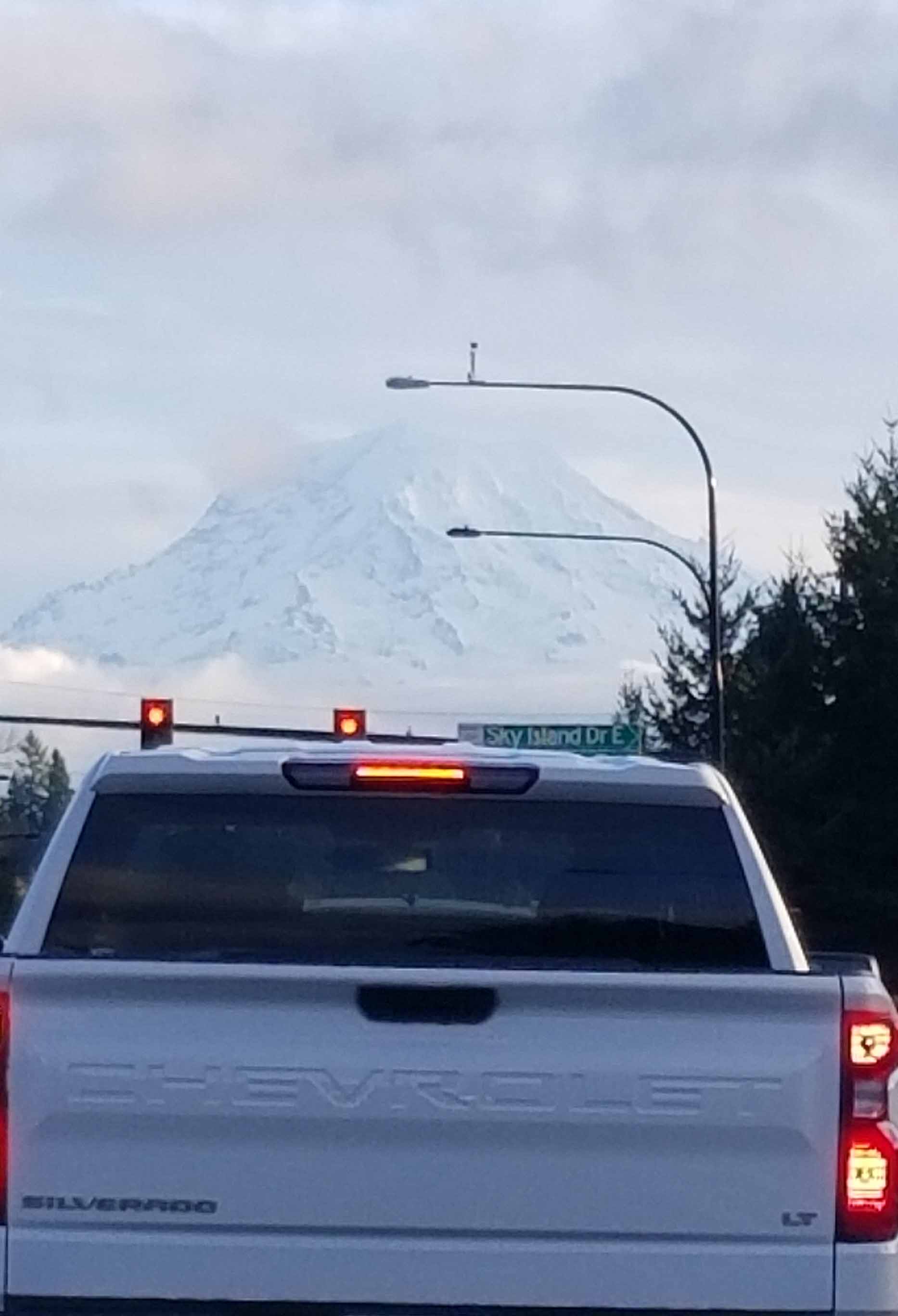
Everything worked out great! The snow conditions were powdery and dry, it snowed all day, and the wind was dead calm. I spent the evening prior in Enumclaw, and headed up starting before 8:00 a.m. Note: The drive prior to Enumclaw is frustratingly stop and go as it passes through a number of suburban malls. But the view of Mt. Rainier is spectacular!

Enumclaw is a poverty of breakfast spots. I drove all around town and found myself exasperated. Thoroughly hangry, I settled on McDonald’s. Then, at the very edge of town on Hwy 410, the road to Crystal, I spied Charlie’s Cafe, which otherwise would have been my salvation! Next time!

The initial phase of the drive to Crystal, on SE Enumclaw-Chinook Pass Rd., isn’t all that pretty. It has equal amounts forest, mountain views, and unsightly clearcuts.

Further along, the forest closes in, and the road winds along the beautiful White River. It was snowing, still, and the flakes piles up on pine boughs and deciduous branches. Bridges were all covered in sugar.

Crystal is nestled in a narrow valley and there is only a two-lane road accessing it. I was skiing on a Monday, but I could only imagine the crush of Seattle skiers on weekends.

The serendipity of the ride was interrupted toward the last turn off which brings one to Crystal Mountain Boulevard. Traffic was halted due to an unknown hazard ahead. In this valley, I had no cell phone reception, so the only news came from drivers headed back my way. After about 30 minutes, word arrived about an SUV overturned on the access road.

It seemed like the morning was getting late, but in fact it wasn’t even 8:45 yet. Lots time to get turns in!

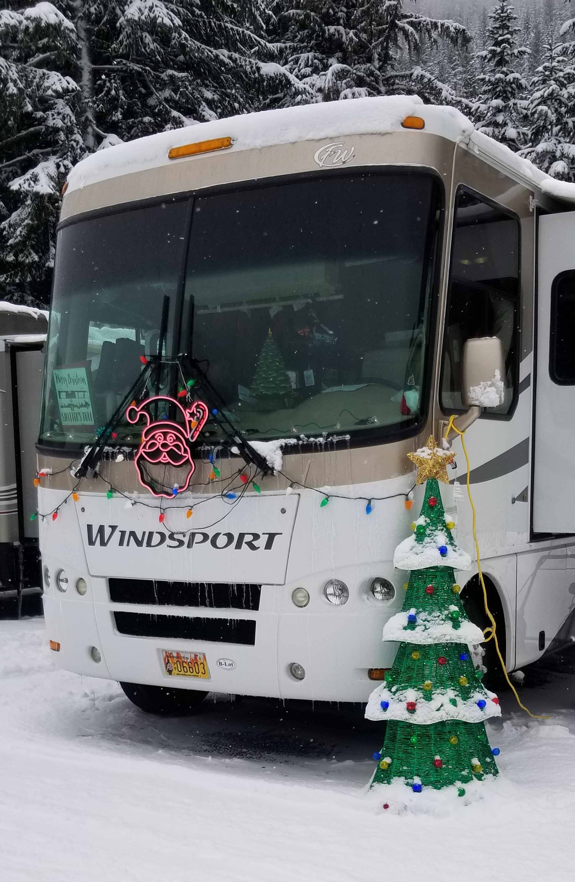
After all the excitement I reached Lot B. As it’s in a narrow valley, parking lots are stretched out along the bottom. Numerous shuttles ferry guests back and froth from the base to the lots. Quite a number of RVs overnighted. Some dressed for the holidays!

My IKON Pass is supposed to be valid at over 40 resorts worldwide. I just had to verify at the lift ticket window that this thing is real. YES! It does work! So it was off to the lifts. Crystal tops out at 7,012 ft. It has a sh*t ton of in bounds skiing that would be outback elsewhere, including the lift-serviced Northway Area, which the trail map says is “All avalanche prone.”

Crystal has a Gondola, which is a fast way to get from the base area to the main mountain. I didn’t take it, still avoiding un-masked rides in close quarters during Covid.

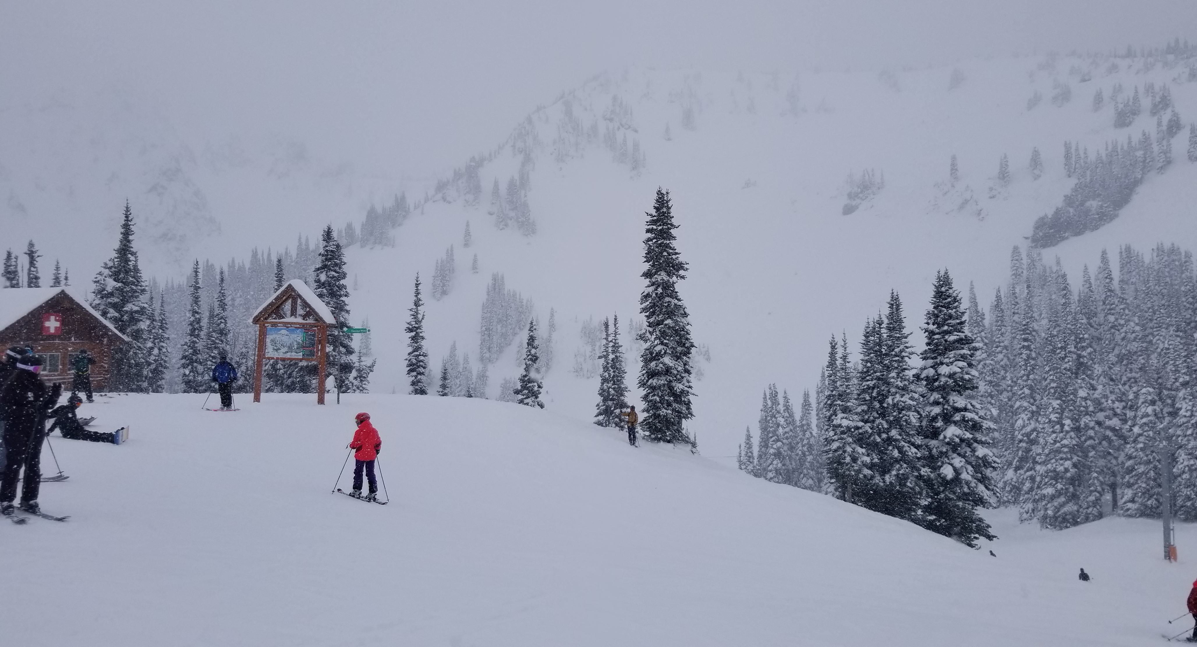
I spent my day between the Chinook Express, Forest Queen Express, and Rainier Express lifts. It was such a terrific day with an embarrassment of powder snow! 1,000 giggles all around. The trails have terrific fall lines and there are lots of bowls and tree skiing! I’m definitely heading back to explore more.

The snowy drive out of the valley was to die for! But back toward Enumclaw, it was all rain. I will return to Crystal later this winter for sure!


Waldo Lake, OR – Beautiful Paddling and Starry Nights

13 09 2018

20180804_095403

Waldo Lake, located about 50 miles east of Eugene, is one of the most pure lakes in the world. It’s one of Oregon’s natural wonders. For sailors and paddlers Waldo Lake is a dream. No powerboats are allowed. So it’s like going back in time. It has no incoming streams – it gets its water from springs and snowmelt only. In fact, the water is so pure, fish cannot live there. Gliding over its surface, you can see 140 feet down. I’ve been going there for years, because the camping on the west side is paddle-in only. Recently, though, forest fires seem to crop up in mid-August every year sending smoke. So there are campfire prohibitions on that side. So this time we car camped on the east side. Because Waldo sits at 5,240 feet altitude, snow melts late and mosquitoes can be a problem in early summer. With the bugs early and fire smoke later on, we decided to visit in early August rather than around Labor Day, as we’d normally do. We lucked out. The bugs were not bad and we had clear air.

I set out with Jessie and her brother Joel. We stuck three kayaks on the roof of my Ford Escape and packed in all the gear. We set out to snag a camping spot. Bill Baxter and Julie Dale would join us the following day.

I’ve never made camping reservations and as usual it worked out this time. We camped at the North Waldo Campground. It’s got a lot of lakeside sites but they were all taken. Still, we got a site just across the road, within walking distance to get our boats to the shore.

After setting up camp, we “slothed” around, reading and relaxing. It was so beautiful by the lake. There were a number of different types of clouds, cirrus, and cumulus. It was fun to watch the little cumulonimbus clouds build. None reached thunderstorm strength. Then, after dinner, we went down to the shore. One by one, the planets came out. We saw Venus, Jupiter, Saturn and Mars all at once. Then the International Space Station flew over, and then according to my Star App on my phone, the Hubble Space Telescope too! The Milky Way was so magnificent. And with my powerful binoculars we could check out nebulae.

Next morning, after breakfast, Jessie and I set out to explore the shoreline to discover new campsites. We didn’t really find any on the east shore. We did find some beaches and lunch spots though!

Our paddle took us all the way across the lake, not far from Rhododendron Island. It was much farther than I remembered. By the time Jessie and I made it back to our starting point it was after 2:00. We were both exhausted. After wolfing down lunch I took a stroll exploring the campground. When I returned Bill and Julie had arrived! We all had a gregarious afternoon and evening. We checked out the stars again and did another paddle.

20180805_090936.jpg

Next morning we gobbled up everything and set out for another day on the lake. There is no doubt that camping coffee is a nectar of the Gods that can’t be beat!


Peru: Cordillera Huayhuash Trek – To Cuartelhuain

20 07 2017

Last night’s dinner at the Club Andino Huaraz was simply exquisite! With the exception of dessert, which was apple pie, I feasted on Peruvian delights. The starter was a Causa, which is layers of magically whipped and seasoned potato separated by choice of chicken, shrimp, or perhaps trout, kicked with Aji Amarillo – a type of chile. If is absolutely to DIE for if you ever get to Peru. Did you know Peru has more than 4,000 types of Potatoes? Next a bit more emotionally difficult choice – Alpaca. It was thinly sliced and kind of like a combination of steak, lamb and maybe a bit of bacon. Good!


causa

A Causa featuring shrimp.


OK, then dessert, and of course some Peruvian Malbec, made me ready for bedtime. Tomorrow, it would be a 5-hour drive to 13,776′ camp at Cuartelhuain! This would be camp #1 from which we’d be trekking. The drive, plus today’s hike to 12,650′, and spending the evening in camp, would aid our acclimatization. So, back in the hotel room, it was time to sort thru stuff I’d leave at the hotel, and the stuff I’d take on the trek.

I brought an extra light duffel and lock for the hotel storage part. I’d leave stuff like wall electronics chargers, my passport, tips for my guide, city clothes, some tourist booklets, and most importantly as it was going to turn out, an end-of-trip change of FRESH clothes!

After a 6:30 a.m. breakfast, it was time to board the bus, which would take us on the long and windy road to camp.

Cuartelhuain Drive3

The road left Huaraz, paved, but would eventually become rock and dirt, descending and climbing steep canyons. Sometimes the bus would scrawl underneath overhanging boulders!

All along the way we’d glimpse numerous what I’d call ranches at river bottoms, where cattle gathered to eat the grasses.

This was a one-way road. Coming round a bend, we’d sometimes encounter a vehicle going the other way. We’d stop. Back up, and find a “shoulder” so the other vehicle could pass. Everyone was OK.


Cuartelhuain Drive4

Like the Himalayas, the Andes lifted ocean crust, resulting in unimaginable twists in once horizontal rock layers.


The Andes rose some 70 million years ago due to plate tectonics. The Pacific Plate came into “combat” with the Nazca Plate. And from that point on, the sea floor rose, which was to become the 20,000+ ft Andes, the longest mountain chain on Planet Earth. We’d find ocean fossils on our trek.

This drive took us to our first views of the steepness of Andean Valleys.

Cuartelhuain Drive1

The heights of the peaks, the depth of the valleys, and the amazing clinging villages in between are images we’d glimpse for the next two weeks. Ha! And, oh yes. We’d be trekking/climbing those very same places with our own two legs, lungs, and hearts!

Cuartelhuain arrival

OK arrival at Cuartelhuain – our tents all set up and our duffel bags inside, ready for our first night’s camp. As you can see, all is SUNNY, I am still in shorts, regardless of the 13,776′ elevation. Snow? Not at this level. This is pretty as it would be the rest of the trek. Late afternoon, warm. But once the sun falls below the mtns in the valley, a BIG CHILL starts. Time to layer up. Tomorrow, it’s up to the Continental Divide at Cacanampunta Pass which is our 1st big one at 15,387′!!!!

When it comes to dinner, Cathy Ann Taylor’s mantra is “Eaters are Succeeders,” so no problemo asking for 2nds!


Columbia Gorge Hikes: Eagle Creek

12 06 2017


IMG_0268

A typical trail side view.


No visit to the classic Columbia Gorge would be complete without a hike up the Eagle Creek Trail. Only 30 minutes from downtown Portland, Oregon, Eagle Creek offers complete refreshment for urbanites in need of a re-set, and amazement for tourists in search of views, waterfalls, ospreys, bald eagles, salmon and more.

Starting at its confluence with the Columbia River, Eagle Creek Trail gently ascends, reaching more than 800 ft in elevation, connecting with other Mt. Hood National Forest trails. The trail could be characterized as canyon-climbing and forested, with waterfall views dotting the way. It contains the classic Punchbowl Falls, often seen in kayak photos.


IMG_0264

Punchbowl Falls


Eagle Creek Punchbowl Falls

On virtually any day in any season, a Columbia Gorge hike can be great. But it gets more complicated than just heading into the Gorge. Some hikes like Coyote Wall (in previous blog) are good for early spring. On warmer days these trails – with little shade – can become like solar collectors. Hikers roast. So when it heats up,  Eagle Creek Trail is a good choice.


IMG_0267

On the steep canyon face, Laura enjoys the fresh water cascading from above! There is a cable to grasp for safety.


It offers a forested canyon with a north-south orientation. So, while it might be a bit cool on rainy spring days, it is sublime on hotter summery days.

IMG_0257


IMG_0259

Wildflowers take advantage of our wet spring.


IMG_0265

One of the side creeks the trail crosses.


OK – I’ll let this blog be brief. Eagle Creek is a must for a visit to the Columbia River Gorge! Don’t miss it. You’ll be greatly rewarded.


Columbia River Gorge: Hiking the Coyote Wall / Labyrinth Area, WA

1 06 2017

20170403_113518

Like the Lower Deschutes River area, the Washington side of the eastern Columbia River Gorge offers beautiful spring hikes with lots of SUN, whereas it might be cloudy in the Portland, OR area. This spring, I discovered the Coyote Wall / Labyrinth trail system.

To reach this beautiful area, take I-84 east from Portland, and cross the Hood River Bridge to the Washington side. Head east on Hwy 14 past Bingen. In about 3-4 miles you’ll encounter a lake on the left. That’s Locke Lake. To reach Labyrinth you’ll have to walk along the north lake shore road maybe a mile to get to its trailhead.

The Washington side of the Eastern Gorge is ideal in early spring because like a solar collector, it faces south, it is sparsely treed,  so it gets lots and lots of sun. This trail system climbs some 1,775 to max out at 1,895 ft elevation. It is shared by mountain bikers and hikers – and their canine friends.

If you like waterfalls, sparse trees, immense views, and wildflowers – and who doesn’t? This system is for you. But if you cannot handle some climbing be warned. It may be that the beauty will just carry you through.

I had recently been to the next-door Catherine Creek trail system. Catherine Creek is so open as to be boring in comparison. Catherine Creek has vast open fields which seem to go on forever. Alternatively Labyrinth has countless micro “worlds” filled with little canyons, trees, flowers, waterfalls and views popping out. Each one different.

DSCF2096

It’s possible to lose one’s way up there, so I suggest consulting an online guide with detailed instructions before heading out.

Laura and I encountered countless wildflowers along the trail.


One after the other, these little canyons keep coming, and then, the trail leads to an eye popping view of the entire eastern Columbia River Gorge. The trail eventually leads to the Coyote Wall, which is an escarpment some 70 feet above a valley and goes along a mile or so.

DSCF2098

Now, that’s a time to pause, relax, and take stock of life for a bit! On this day, we were really fortunate to be treated to calm winds. And, the hills were literally “flowing,” draining the burden of the spring rains!

In mid-summer, like many places in the eastern Gorge, this place bakes. So at that time of year, I’d probably pick another hike. But perfect in spring!

DSCF2101

That’s 11,240 ft Mt Hood!


Overnight in Ha Long Bay, Vietnam

6 01 2017

20161120_132529

No visit to Vietnam would be complete without a visit to the emerald waters of Ha Long Bay. For many, their only familiarity with it comes from the silver screen. Ha Long Bay has been depicted in “Pan,” “Tomorrow Never Dies,” “Indochine,” “The Quiet American,” and the soon to be released “Kong: Skull Island.”

20161121_070535

The many “junks” carrying visitors.

A World Heritage Site since 1994, Ha Long Bay is some 2,000 limestone islets, most rising vertically from the sea topped with rain forest. They are eroded through countless eons into fantastical shapes. This archipelago forms the most popular tourism attraction in northern Vietnam.  The islets have been taking shape for 500 million years.These islands are literally like giant rocks rising from the sea. Some of them have big caves and grottos.

20161121_094319

While most are uninhabited, there are a few with beaches and residents. It is beautiful. And ethereal. I felt like I was on another planet altogether. There are activities, rock climbing, snorkel and scuba, cave viewing, hiking, kayaking and beach combing.

20161120_165614

The best way to view the islets is by kayak!

Although there are day trips one can book, Ha Long Bay is best visited as a complete overnight. This allows for some activities but also to see the light bathing the islets at different angles. There are all sorts of overnight “junks” one can take. Most have very good dining.

20161120_132107

As  you can see, everyone is BUSY chowing down! Fried whole fish, steamed shrimp, and stuffed crab were on the menu.

Some are only 10 guest rooms, others are 4-decked monsters with pop-out stern docks from which inflatable skiffs and kayaks can be launched.

20161120_120811

My room was plenty big.

Thankfully, the beauty was never spoiled by the noise and smell of wave runners or jet skis. And in the evening none of the party boats had loud karaoke playing. And the stars came out.


We were really looking forward to some time on the water. Not long after our boat launched, we took advantage of the roof top lounging area!

It is true Ha Long Bay is popular with tourists. Don’t expect to have it all to your boat. Your boat will share with dozens of others. But it’s still worth a trip. For a more intimate experience with the limestone islets, book a two-day trip to Bai Tu Long Bay. You’ll spend more, but the extra Dong will buy you more solitude.