Trinidad, CA – A Slice of Coastal Heaven

13 10 2016

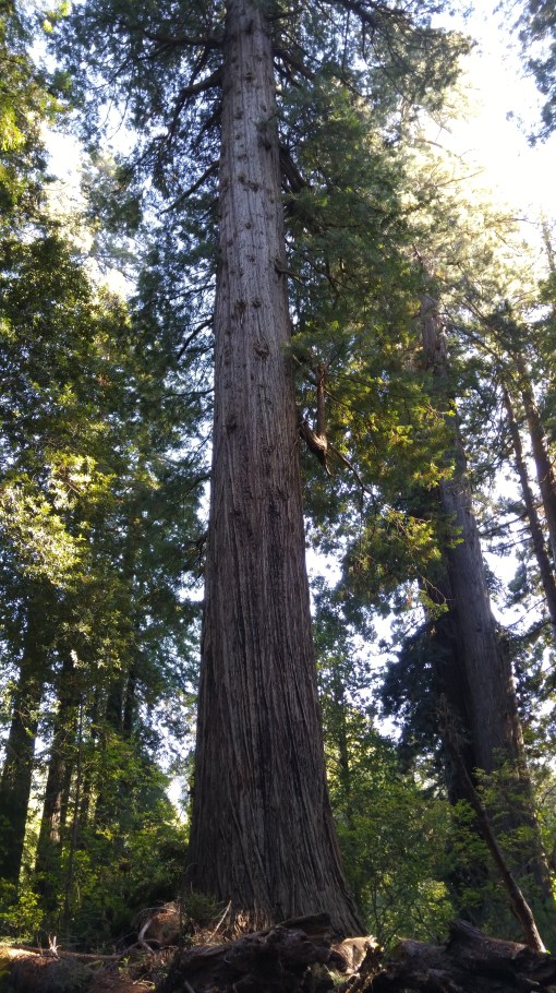
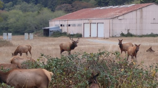
My visit with Jason Self and Shay Bickley in Trinidad, California, was more than hikes among Redwood giants and herds of Rossevelt Elk. The region sports some of North America’s most spectacular coastlines!

20160912_182048

Near Crescent City

Foggy and rugged, thickly forested, and impacted by frequent Pacific storms, this coast shows off when the sun pops out. Highway 101 passes through this region, tracing its line along surf beaches, through dark redwood forest, climbing to 800-ft above the sea before opening up to spectacular unlimited vistas dotted with sea stacks.

We spent a sunset hiking along the beach, and another afternoon walking to a point high above the waves. No matter what route you pick, rewards are rich.

20160913_182054

Man’s Best Friend waits for his family to come in.

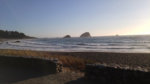
One evening we took a pre-dinner stroll along the shore near the Moonstone Grill, a terrific restaurant with an unmatched Pacific View. It was surreal. No wind and calm seas. So beautiful!

20160913_173753

20160913_182204

The incoming tide was mesmerizing. I could look down on the wavy sand, and see, with each passing wave, how the water was navigating its way further and further ashore. We found a few stranded sea creatures and set them back into the ocean, much to Shay’s delight.

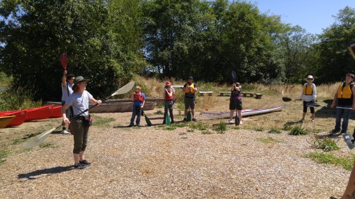
The following day was to be our paddle on the bay. Days here often dawn in a pea soup fog, but most of the time, that fog loses out the the sun by mid day.

On paddle day, there was barely any fog at sun up.

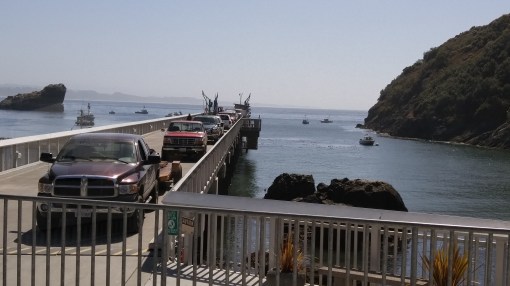
We breakfasted, loaded the boats on the cars, and partially donned out dry suits. Then it was time to head to the bay.

The town of Trinidad leads to a peninsula – with beaches on the NW and SW sides. On this day the swell was coming in from the NW.

20160913_131956

The sea laid down for us!

dscf1903

Shay readies the P&H Delphin.

dscf1912

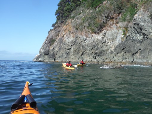
We launched on the protected SW side – which, I’ve got to say, had become an undulating lake! We got maybe a mile or one and a half miles down the shore, paddling amongst sea stacks and harbor seals, before the swells were bigger, and I could see waves crashing against rocks. Even with the small seas, they were quartering from behind, and I got a weird feeling like the sea was a magnet, and I wanted to fall in. Jason said it was a touch of vertigo. I have had vertigo sensations before, but never at sea, and I’ve never been sea sick. Turning around, facing the swell, completely reversed that feeling.

dscf1907

A bay of kelp and harbor seals. And, as Jason says, sharks.

dscf1908

We checked out the sea stacks, rocks, and took a “stroll” along a cliff face. There, we found murrelets, more seals, and a couple of otters! One otter came out of a little cave. Another had caught a fish, and was hurriedly eating, as if it were concerned a rival might try to steal its catch.

20160913_101856

And Jason LOVES his recently acquired P&H Hammer, but not having his photo taken! It was a memorable day on the big P. I hope to visit again!


Northern California Coast: Walking Among Redwoods

6 10 2016

In September I had a 5-day span between work shifts, so I decided to visit Jason and Shay, friends from Portland who moved down to Trinidad California a few years back. They now live in God’s Country – with access to breathtaking coastal scenery and unlimited access to Redwood National Park.

The time down there would be spent beach combing, kayaking, sampling the local cuisine, and walking beneath some of the world’s tallest trees. In this post I’ll cover the redwoods. Next post – the coast.

It’s an 8-hour drive from Portland. The part on I-5 is definitely a slog, but once you cut over to the coast, it’s a treat.

20160912_165108

Highway 199 tracks along the Smith River, famous for fishing, scenery, and rafting. It wends its way right through Redwood National Park. Not long after passing an information center, the giant trees emerge – the highway passing within a few feet of them. It’s impossible to just yawn. No, gaping is the reaction.

Coastal redwoods live to about 2,000 years and reach 380 ft high. They dwarf anything in Oregon. These forests also are the world’s most alive. They have Planet Earth’s greatest volume of living matter per surface area. Everything is growing. And, they are very valuable. The Yurok Native American tribe depended on the redwood groves for everything. But then white folks from back east showed up. Back in the days when people thought America’s natural resources were inexhaustible, big money brought industrialized logging to Humboldt County. Giant Redwoods were no match for the steam engines and trucks that came. State parks and the national parks were established to help preserve a national treasure. Later, on some of the private lands nearby, near violence erupted between environmentalists and capitalists seeking to harvest every last old-growth tree.

Taken together, the coast itself and the redwoods make this a place worth visiting!

20160915_160458

20160915_160314

Walking in the groves inevitably leads to thoughts of The Lord of the Rings. I wondered if J.R.R. Tolkien was thinking about the redwoods when he created the Ents? You can almost hear the trees talking amongst themselves here! Making decisions very slowly, but always wisely.

If the trees are Ents, the deer are Roosevelt Elk. Driving hwy 101, you need to keep an eye peeled at every blind corner because there could be 40 elk in the road!

20160915_180606

Hello! A herd with a nice bull, who was watching over his band of females and their young.

The bull did indeed indulge in bugling. And sniffing his ladies to determine if they were in season.

All for the people in their slowed-down or stopped cars to watch. This herd seemed well adapted to gawkers.

20160915_180226

20160915_175848


It’s a family thing!

In sum, I’ll have to return! A beautiful area to visit. Next post we’ll get into coastal walks and paddling!


Kayaking in the Footsteps of Lewis & Clark

6 09 2016

I have lived in Portland, OR for years, but I’d never visited Fort Clatsop, where Lewis and Clark spent the winter of 1805-1806 following their Voyage of Discovery across the American continent. This summer I made plans to see the place. A little research revealed that besides the fort, there is also a free historical kayak tour. So my friend Jessie Bader and I made plans to make a trip out there.

Fort Clatsop lies on the Oregon Coast, near the mouth of the Columbia River and Astoria, Oregon. We decided to overnight at Fort Stevens State Park Campground. Our first day, we arrived in mid afternoon. So we set up camp and, with plenty of time, headed to Astoria to check out the waterfront. Our kayak tour was the following day at 1:00.

First up was ice cream. Cones in hand, we headed down to the riverwalk along the Columbia River. The Columbia River Maritime Museum, with exhibits like a full sized Columbia River Pilot Boat beckoned. We debated and didn’t enter. But behind lay the Columbia Bar Lightship and the Coast Guard Cutter Alert.

20160803_155710

Just a few dozen yards inland we discovered the Astoria Riverfront Trolley. It is super cheap $1 a ride. It glides along the waterfront running to the end of the line east. Then it reverses and goes to the western end of the line, in town. The seats are benches, with a twist – literally. When the train needs to head the other way, passengers get up, move the seat back the opposite way, and sit down facing the new direction.

20160803_143222

The streetcar showed me some new things about the waterfront. It gets much closer to the docks than the road. There are a number of piers with restaurants and recently opened breweries on the piers.

20160803_143022


We got off and took a stroll down the waterfront.

It was a really beautiful August afternoon. A sea breeze blowing. On such a pretty day, it was easy to forget that Astoria spends most of the year in gray stormy conditions.

But on that day, all is forgiven.

Not so for the Lewis and Clark crew in 1805. For they arrived in the winter season. The expedition spent 106 days at Fort Clatsop, it rained every day but 12 and they saw the sun a total of six times. It’s no wonder they gave names like “Dismal Nitch” to landmarks in the area.

Today, Fort Clatsop is administered by the National Park Service. It’s got a museum, gift shop, and dedicated guides to share information on the place.

One of the most popular attractions is the daily loading and shooting of a musket. At 10:00 a.m. a guide gives a talk on the uses of fire arms back in those days, and the way people loaded and fire them.

20160804_103600

After the musket presentation was finished we took advantage of a half mile guided nature walk. And then, it was time for lunch. We found a thoughtfully constructed picnic spot nor far away. On this day it was Euro style, cheese, hard sausage, crackers, fruit, nuts, etc.

20160804_123207

Then we met the tour down at the put in on the Lewis and Clark River. The group would be a family, a couple of individuals, plus Jessie and I. We had two guides, Pat and Cadence.

20160804_134733

A bit of paddling 101 instruction by Cadence got the group started.

The river here is completely tidal. At low tide, much of the area is mud flats. So, the time the tours take place vary all summer, to coincide with high tide. Reservations are required. Our tour was full. We had some lively children, and Pat wasted no time in gaining the upper hand. If they even so much as yawned or stared away, she snapped “A-tten-sion!!!”

On the water, Pat immediately dropped her VHF radio and it was gone, stuck on the bottom. “Well, that’s my second dropped. They’ll fire me!”

With everybody launched we made a three-mile paddle.

20160804_151459

At various points we gathered for a little talk about conservation, or the challenges Lewis and Clark faced.

20160804_142954

The Park Service has purchased additional land adjoining the original site, and has done a good job restoring its property to the way it looked back in 1805. Wildlife has taken note. Many species of birds have returned. Elk and deer are more common.

If you are in Astoria, or camping at Fort Lewis, a stop at Fort Clatsop is definitely worth your time!


Granite, OR – An “Almost” Ghost Town

31 08 2016

Granite town sign

On our North Fork John Day River trip, we’d made up our mind to head east to Anthony Lakes, OR. The route passes straight through Oregon’s forgotten past – its 19th Century Gold Rush region. The spotlight was thrown on this region on Independence Day July 4th, 1862, when A.G. Tabor struck gold on Granite Creek. Today, there are still active mines and claims being worked!

Mining Posted

Just like a Clint Eastwood film!

Word of Tabor’s strike spread like lightning, and within 10 years as many as 5,000 hardy fortune seekers and their families had descended on Granite. More towns emerged, with names like Sumpter, Greenhorn, and Susanville. Folks from back east, European immigrants and Chinese all came. The area was a cultural hot spot until the early 1900’s. Dance halls, bars, pharmacies, general stores, churches and more served the families, with more than 80% involved in mining.

Fortune seekers worked the land in any number of ways. Some worked in “placer mines,” which is essentially mining a river bed. It might involve hydraulics blasting jets of water to excavate. Or, simple panning for gold. By 1914, placer mining had found over $2,000,000 of gold in the North Fork John Day River and Granite Creek. In other places mines were dug into hillsides in search of veins of gold. Some of these can be seen today.

Granite Mine

I don’t suggest exploring this old mine!

It was a tough life. Work was dog tired hard. And dangerous. Winters brutal. It was remote. Granite’s telephone and electrical service were cut off after WWII. Well, the telephone returned in 2000. These days, there is a single wireless router that operates intermittently from the telephone switch box.

Granite Bell Tower

Granite Town Hall.

By 1960, Granite almost joined sister towns of Greenhorn and Susanville as ghost towns – its population had dwindled to 2. But by the 2010 Census, Granite’s population swelled to 38!

Today, there are two businesses in Granite. The Outback, and The Lodge. The Outback Gas and Supply Store was our only resource out here. It has a closed down cafe in the rear. Out front it’s got limited supplies of fishing and camping gear, plus non perishible foods, toiletries and some ice cream. As we were car camping in Anthony Lakes, I was seeking something for the barbeque. When asked, the response from the owner was, “Well, you know, we haven’t got much. This IS Granite after all.” She dug out a package of hot dogs, but they were past the expiration date. However, she was resourceful, and managed to dig out some hockey puck hamburgers from the freezer. Well, with that my only option, I went ahead and bought them along with some gas, and a few supplies. Total bill was $36.

Outside, Laura found something familiar in Portland! A Little Free Library!

Little Free Library Granite

Granite General Store

This was the old Mercantile Store.

Despite the remote living and challenges of survival, people kept going. Families had kids – but the mortality rate was very high. The palpable evidence of hardship was illustrated by our walk of the Granite Cemetery. Way back when, folks often listed cause of death on tombstones.

“Suicide.” “Mining accident.” “Bear attack.” Plus diseases. Not all the headstones had a name. For us, the most heart rending was a section for infants and still births. There were so many who died at birth. Or in the first week. Clearly, life was tough.

Headstone

Laura and I walked what is left of Granite. Many homes in a state of near collapse. But others showed signs of care – many in a state of “project” status. So, Granite still is home to about three dozen souls! It escaped true Ghost Town status!


North Fork John Day River Backpack

26 08 2016
River Evening Peaceful

The peaceful nirvana of early evening at the Oriental Springs Campground

In July, Laura and I planned to backpack a 10-mile section of the North Fork John Day River in central eastern Oregon’s Blue Mountains. The entire river is a nationally designated wild and scenic river, so we were very excited! I had hiked the eastern portion back in 2014. This time, the plan was to try hiking from the western end. The whole trail, some 50 miles, is steeped in gold-rush history. Back in the 1870’s gold was struck in the area, and thousands braved the wilds to strike it rich. Today, although the big mines are mostly gone, there are still active mining claims with people panning for gold! I’ll post a blog about that next. But for now, it’s about the backpacking.

This hard-to-reach trailhead and backpack had been on my list for many years. It took about 5 hours from Portland. Even when you get off the state road, the dirt road/4WD track to the last campground and trailhead is many miles. Due to the long drive, we just planned to car camp the first night at Oriental Springs Campground. Arriving about 5:00 p.m., the heat of the day had passed. The river sits in a tight valley, and the shadows were already beginning to lengthen.

Oriental Campground 
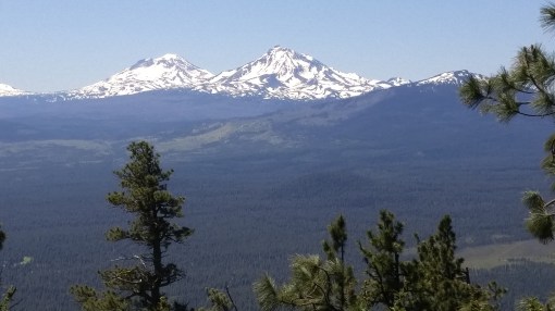
We had the whole place to ourselves. There were lots of puddles on the road – and blow down. There must have been a recent thunderstorm. Though most of the area was dry and dusty, the evidence of rain was there. Despite the standing water, there were no mosquitoes. Lucky us.

Laura found the campfire to her liking! Laura Fire Oriental Campground

In the morning, we sipped coffee, ate breakfast and packed up.

It was a moderately cool morning. Very pleasant!

Not in a hurry, we didn’t plan on hitting the trail until maybe 11:00. Big mistake.

Laura packed for backpack

Packed up and ready!

With the car locked and packs filled, we hit the trail. My research revealed that this is bear and cougar country. So, we both wore jingle bells on our wrists and used trekking poles, which made us very noisy to any hungry or motherly creatures out there! And merry makers to others.

Bear Bells

Bear bells highly suggested!

The trail lies on the northern (i.e. sunniest) side of the river. The forest here is amber-colored bark Ponderosa pine. If you’ve never been in a Ponderosa pine forest – I need to describe. Instead of tightly laced tree branches typical of Douglas fir forests – which are shady and therefore offer a cooling effect, Ponderosa pines are spread farther apart, with not nearly as many branches between trees touching. Hikes in Pondersoa forests are more vulnerable to hot sun. This one is no exception.

The valley slopes reached skyward immediately from the northern side of the trail. Soon,  the place became a convection oven! We had no relief from the sun or the broiler-like hillside next to us. But there was more. There was winter blowdown. Packs on, we climbed over or slithered under fallen trees.

It didn’t take long for signs of large wildlife to appear. The recent rain and puddles left some flat, muddy areas. Anything walking over would leave footprints, betraying its presence. We noticed deer, elk, and then – bear and cougar prints!

Bear Track

No doubt about what left these prints!

Not long after, and right smack in the middle of the trail, we saw a pile of poop. Not just any pile of poop. Because whatever this creature ate it was full of seeds! Bear scat. Between the trail and the river at this particular point is an area full of blackberries. No doubt this bear was feasting.

Heat aside, it’s a very beautiful river. It winds lazily along, and except for some deeper pools, it’s about 2-3 feet deep. But the heat quickly got to us. We found an open place for lunch and discovered it was a camping spot. It didn’t look like it had been used recently because growth was starting to cover the fire ring. As hard as it was to accept, we actually decided to base camp here. It was a place that offered shade!


Feeling guilty and pretty annoyed about the heat and the fact that we’d only covered 2.5 miles, we decided to hike further up the river. What we discovered unexpectedly justified stopping to camp were we did.

We didn’t find anywhere suitable to camp. And grass plus brush had assertively grown across the trail, about knee high. We wore shorts. And I’d heard stories about lots of ticks from other hikers recently. So we pressed on, but were constantly checking our legs for critters.

Eventually we’d had enough and, frustrated, we started back. Just when we began to get cranky, I saw a possible wading spot. We walked down there and waded out into the river. This was the respite we needed. More, we realized, this what this day was all about. Sitting in the river, with it flowing over our overheated souls, we cooled down enough and it became almost meditative. Impossible to get out.

Laura on rock in river

We spent time here, and then back at camp, spent more time just enjoying the water! Well, what to do with the rest of our time out here? We decided to get on the trail early the next day, before the heat picked up, hike out, and then drive over to Anthony Lakes and car camp.

Laura on Anthony Lake

An end-of-day happy hour at Anthony Lakes!

Anthony Lakes is a year-round recreational area. In summer there is camping, hiking, boating, and fishing. And even some sailing. It’s elevation is over 7,000 feet, so it’s got dry powder snow in the winter. The Anthony Lakes Ski Area is popular with locals all winter long. Plus, there are lovely Cross-Country trails all around. The stars were really spectacular. All together, we had a nice trip!


Black Butte Hike

17 08 2016

Of the many activities to choose from in Oregon’s Metolius River area, a hike up 6,436 ft Black Butte is one I had never undertaken. Black Butte (affectionately known as “Black Butt”) is a cinder cone, formed thousands of years ago when Central Oregon was much more geologically active. When in the area whether at Santiam Summit, Three Fingered Jack, the town of Sisters, the Metolius Valley, or McKenzie Pass, you can see cone-shaped Black Butte.

I had heard the hike is hard, but the 360-degree views are unsurpassed. So on my birthday weekend, we made plans to undertake it. Bill, Tatsuro and I took the challenge. It was a perfect bluebird day. Turns out much of the hike up is very exposed, so it’s a good thing we started in the morning.

There is a way to cut off most of the way up – because a road switchbacks up to a trailhead about halfway up the mountain. We arrived at 11 a.m., and it was almost filled with cars. Slathered in sunscreen and tanked up with water, we slung backpacks and started up. Lower portions are dotted with many old-growth, wind-blown Ponderosa Pines. It was clear to me that winter winds take their toll on trees clinging to the slopes.

20160612_115923

We were at Three Fingered Jack yesterday! Wow.

When we first emerged from the lower forest, we were rewarded with a view west – Three Fingered Jack! Yesterday’s clouds and fresh dust of snow were gone. But this was but one of many views we were to encounter on the two-plus mile to the summit. Just glimpsing this one added much energy to the quest. The hike is steep! Not for the timid. We met a lady at the trailhead who seemed really focused and let her go on. Little did we know, was doing the trail twice that day! Olympic training?

20160612_120733

Summit fire tower, with hikers below.

The hike is very steep and exposed to the sun and wind. On this day, we had sun and heat. But zero wind. It could have been much more hot. Or windy. We considered ourselves fortunate! And the views? Food for the hike. To the south – a view of geologic history. Newberry Crater, McKenzie Pass, and the Three Sisters!

20160612_120326

North and South Sister. Middle Sister is hidden.

Such beauty is breathtaking! Thousands of feet below us lay the Metolius River Valley and Black Butte Ranch.

But there was much more climbing to go. The trail finally switchbacks its way in a circuitous route eastward and then northward before it reaches the summit. Bonus! This means more views!

20160612_123936

10,450 ft Mt. Jefferson, Black Butte’s northern neighbor.

We enjoyed unlimited views in all directions along this hike, none more spectacular than that of Mt. Jefferson just to the north.

20160612_124715

Tatsuro, myself, and Bill. To the left are the Three Sisters, and on the right, Mt Washington.

Rod Trailhead

I love trails!

A 360 degree view is the treat when you summit Black Butte. You can also see all the way to 14,410 ft. Mt Rainier and 12,280 ft Mt Adams. Wow! We met many people there with lots of stories to tell. We then wolfed down our lunches, loaded up and made the journey home.

This was a birthday hike to remember! On the way down, I encountered the woman doing laps. All she could do was grunt. Well, I Hope to do many more hikes like this one!