Trekking Peru’s Cordillera Huayhuash: To the Continental Divide

29 07 2017

Today’s plan starts at 13,776′ Cuartelhuain, climbs over our first 15,000’+ pass at 15,387′, and then we’ll descend to our camp at Janca at 13,940′. So today is the test I must pass if my conditioning and our acclimatization days have prepared me. I know I’ll see vistas indescribable to people back home, and experience physical and emotional feelings both excruciating and exquisite. And beyond today, there will be more 15,000′ passes and a 16,000+’ pass coming up.

So, what’s starting and ending the day like on the trail? Well, unzipping your tent you are likely to be greeted with eye popping views. And then, staff comes with warm beverages! After that, staff delivers hot water for washing. At day’s end, you arrive in camp with your tent set up and duffel bag inside. Staff brings warm wash water. And then about an hour later there’s “happy hour” in the mess tent, at which snacks and coffee/tea are served.

It chilled off last night to about 30 degrees. Ice crystals formed on the underside of my tent fly. The stars were incredible, with the Milky Way and Southern Cross right on top of us. But as the sun rose, it bathed our valley in motivating warmth this morning. With breakfast done, we are on the trail by 8:00 a.m. We are all dressed in removable layers – because we know we’ll be working hard climbing and the temperatures are going to rise.

We leave as a group. I stick behind local guide Roger, who, I discover, has this amazing slow pace so that we can make it over these passes. He keeps looking back, checking to see how the group is coming along. The other local guide, Anna, plays “sweeper,” going last, ensuring everyone makes it. Right behind Anna is Manuel – who is managing our “just in case” horses. About 90 minutes into our hike, the camp crew comes through with our parade of llamas, horses and donkeys! It is quite a show. This, plus the view, has me giddy. But then something happens. I am exerting so much I can’t remember the name of the trek I am on. YIKES! I realize the altitude is getting to me. And, the urgent breaths, plus the dry air, are making my throat sore. So, I start sucking on one of the hard lemon/lime candies I took for snacks. And I play a game in my head remembering the other treks, the Cordillera Blanca for example. Then it comes back, I am on the Cordillera Huayhuash. Well, that was alarming. But at least I was cognizant enough to be alarmed!

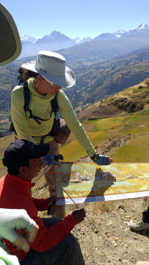
After a rest stop, Cathy Ann reminded us to pay attention to our steps and our breathing. Remember, the breathing gives oxygen to our legs! Sometimes, too much talking or socializing takes a toll. So right now, I pay strict attention to breathing and to matching Roger’s footsteps. Then I notice way up ahead – WAY UP – our crew hiking with the llamas! OMG. That means WE have to hike up there. Then somebody calls out, “Condors!” Just glimpsing these incredible creatures gliding up above made me temporarily forget my challenges. And then, Roger points to the pass. I will make it!

We make this 1st pass! This is the continental divide of South America. To one side, all rainwater goes to the Pacific. The other – to the greatest river on Planet Earth – the Amazon. We’d linger up here some 15 – 20 minutes, and then, time to descend to our next camp, at Janca. The hike to Janca was much more relaxing. Once off the pass, it was a long gradual descent.

Cuartelhuain wakeup1

Janca, from my tent!

A well deserved relaxation at Janca would be in store. There, we’d be treated to views of 19,000′ plus peaks of the Cordillera. I’d get my hot wash water, and then a nice hot beverage social hour after that. Trekking is good!

Janca shave

That hot water is most welcome. Time to wash up and heck, why not have a shave!

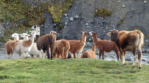
Our llamas are a bunch of characters. They hang out together, and once in a while, local “folk” greet them and ask how things are going.

Janca Llamas2

The light made for some sweet photo taking opportunities.

Janca Andrew M

With dinner finished, it’s time to bed down because tomorrow promises a day packed with adventure! We are told tomorrow’s lunch, and camp, offer unsurpassed views.


Trekking Peru: The Cordillera Huayhuash – Acclimatization Days 1-2: Huaraz

10 07 2017

20170619_100215

Here we go! This the first of about a dozen blog posts covering my June 2017 trek in Peru’s Cordillera Huayhuash! This was a big deal. Back in 2007 I did a Himalayan trek of Bhutan’s Chomolhari with Cathy Ann Taylor, and it stuck prominently in my mind. I watched her Cattara website for an Andean trek and when this one popped up I jumped at it!

These treks are simply the “bee’s knees” of hiking/camping trips. They involve undertaking the “ultimate challenge” level of athletic perseverance and mental toughness. Hiking 8 a.m. to 3:00 p.m. day after day at altitudes ranging from 13,500 – 16,404. All that effort is rewarded with beautiful, dry weather, flowers along the way, and views so spectacular as to literally defy description. But there is more: You don’t have to carry a big pack. Or cook. Or set up your tent. Staff brings coffee/tea to your tent to awaken you in the morning. And, they bring you hot wash water morning and after your hike. On this trek, we even had a portable shower – and one of our stops was at a thermal bath!

Why do these treks? I’m sure everybody has their own reasons. For me, it’s the chance to see mountains so big they are unimaginable at home. To conquer the athletic challenge. To completely disconnect from the snowglobe of distractive thoughts and temptations that are the Internet, e-mail, news, and ties to home. To peel off layer after layer of that routine, getting to the core and reconnecting with natural rhythms once again. For it is only then, free of the pull of those “can’t waits,” that things start to get back into perspective.


Huascaran from Airport

22,205ft Huascaran towers over the airport at Huaraz, Peru


There would be 13 trekkers on this trip. We all flew into Huaraz to meet Cathy Ann (CAT). Our first two days would be acclimatization days, staying at the Hotel Club Andino. Huaraz, with a population over 100,000 sits at 10,150ft. At this altitude even climbing the hotel stairs was a struggle! But we’d have to do more – for our very first camp would be at 13,776ft!

Hotel Andino is a Swiss-owned Euro-style hotel perched on a hillside street at the top of town. Rooms have a mountain view and the restaurant is 1st rate.


20170618_064954

View from my room!


On day two, the plan was a 4-mile hike at Huillcachocha Lake, up to 12,650 feet. We hiked to a rock where Inca sacrifices were performed. From this hike, we had horizon to horizon views of the entire Cordillera Blanca Range! And we encountered some local families going out for the day.

Family_edited-1

To me, the thin air and exertion of this “warm up” hike seemed like the max. But I knew in the next two days we’d be hiking to over 15,387′ and yikes. Can I do this? Will I make it?

The staff was excellent, making a slow, do-able pace. And they let us take breaks to get water, snacks, and adjust our clothing. The views would be one thing that would keep me going!


Cordillera Blanca Pano

View of the entire Cordillera Blanca! It’s the range next to the Cordillera Huayhuash.

CAT shows map

CAT and our local lead guide, Roger (pronounced “Roher”) of ExplorAndes, show us a map of the area

Rod and Anna

Myself with Anna, local Assistant Guide

So, how much equipment, staff and stuff did this 12-day expedition take? 10 Llamas, 16 donkeys, 2 “emergency” horses, 13 staff, kitchen tent, meal tent, a dozen or so Eureka! tents for guests, plus food and emergency gear. Yes, we had supplemental oxygen just in case. Quite the production!


The day’s acclimatization hike complete, we enjoyed a terrific welcome dinner at the hotel. Tomorrow, we’d be off on a 5-hour drive to our first trek-camp!

So, you may ask, “How do I prepare for such a trip?” Answer: 4 months of preparation. Lots of cardio. Running is fine, but about six weeks before the trip, switch to hour long hikes/walks. Four times a week. Hikes with elevation gain are the best preparation because instead of static roads, you’ll get the benefit of walking amongst rocks and such. Even better, hike with a 20 pound day pack. Because on the trek, you’ll be carrying a day pack with rain gear and layers, plus two liters of water.

OK, upcoming are a series of posts from the trail! Passes, 20,000 foot peaks, avalanches, glaciers, emerald lakes, Llamas, and flowers galore! Stay tuned.


Hiking the Lower Deschutes Canyon, Oregon in Spring

30 05 2017

20170327_132533

The winter of 2016-17 brought record rainfall to many parts of the Pacific Northwest, including Portland and Seattle, which saw all-time records for the October – April periods. It was great for skiers. Great for replenishing reservoirs. But it. Just. Kept. On. Raining. Sometimes, the only way to escape Portland’s gloom is to head east, past the Cascades. There, the clouds part and it’s likely a sunny hike can be had!

There are many good springtime hikes in the eastern Columbia Gorge. Wildflowers start coming out in March and peak sometime in late April. One nice choice are the trails along the Lower Deschutes River Canyon. There are three main trails leading from the mouth of the river. One is an old railroad bed converted to a bike trail. Another follows the riverside, snaking along. And a third is in between these two. It is possible to go many many miles upstream following the old railroad bed.

20170327_124653

To get there, take I-84 east from Portland, past The Dalles, to Deschutes River State Park. Park at the area in the southern part of the park.

Laura and I decided to do this hike as it’s a rolling terrain hike and doesn’t involve lots of elevation gain. A loop is possible by taking the river trail about 3 miles to where it climbs and connects with the railroad bed trail.

We had wonderful weather. It was warm in the sun. A train on the opposite side slowly made its way, stopping for a time.

The river was flowing swiftly, emptying Central Oregon of all the excess water from the spring rains.

We saw the occasional balsam root flowers starting to emerge, plus some others I couldn’t identify.

Total hike mileage was 6.5 miles, a good conditioning hike.

20170327_131912

Laura photographs some emerging flowers

The Deschutes River cuts through some of Oregon’s interesting Geologic features. So the trail offers some natural interest. Along the way one can view layers of basalt and ash laid down over millenia. In some spots natural lava bridges formed.

20170327_140413

Weather plus the river have carved some interesting shapes into the rocks here. For wildlife, we saw mostly ospreys and buzzards. Supposedly there are deer and rattlesnakes in the area as well. It’s popular with anglers for the trout and salmon. And backpacking is possible along this trail, too.

20170327_132137

For me, spring and fall are the best times to hike this canyon. Obviously it offers sun when Portland is cloudy. But in the midst of summer, this canyon has three things I don’t like: Intense heat, little shade and often punishing wind. In the summer, it just bakes here. And that heat, which makes air rise, means something has to displace it. And that is air from the Columbia River and the Pacific. In the summer, by afternoon, it can be like a convection vortex here. I have even seen a kite torn from its string! Rafters cannot make progress against this force – often being forced to spend the night and start off in the morning.

So for me, it’s all about the seasons, and this hike is just GREAT in spring!


Kayaking in the Footsteps of Lewis & Clark

6 09 2016

I have lived in Portland, OR for years, but I’d never visited Fort Clatsop, where Lewis and Clark spent the winter of 1805-1806 following their Voyage of Discovery across the American continent. This summer I made plans to see the place. A little research revealed that besides the fort, there is also a free historical kayak tour. So my friend Jessie Bader and I made plans to make a trip out there.

Fort Clatsop lies on the Oregon Coast, near the mouth of the Columbia River and Astoria, Oregon. We decided to overnight at Fort Stevens State Park Campground. Our first day, we arrived in mid afternoon. So we set up camp and, with plenty of time, headed to Astoria to check out the waterfront. Our kayak tour was the following day at 1:00.

First up was ice cream. Cones in hand, we headed down to the riverwalk along the Columbia River. The Columbia River Maritime Museum, with exhibits like a full sized Columbia River Pilot Boat beckoned. We debated and didn’t enter. But behind lay the Columbia Bar Lightship and the Coast Guard Cutter Alert.

20160803_155710

Just a few dozen yards inland we discovered the Astoria Riverfront Trolley. It is super cheap $1 a ride. It glides along the waterfront running to the end of the line east. Then it reverses and goes to the western end of the line, in town. The seats are benches, with a twist – literally. When the train needs to head the other way, passengers get up, move the seat back the opposite way, and sit down facing the new direction.

20160803_143222

The streetcar showed me some new things about the waterfront. It gets much closer to the docks than the road. There are a number of piers with restaurants and recently opened breweries on the piers.

20160803_143022


We got off and took a stroll down the waterfront.

It was a really beautiful August afternoon. A sea breeze blowing. On such a pretty day, it was easy to forget that Astoria spends most of the year in gray stormy conditions.

But on that day, all is forgiven.

Not so for the Lewis and Clark crew in 1805. For they arrived in the winter season. The expedition spent 106 days at Fort Clatsop, it rained every day but 12 and they saw the sun a total of six times. It’s no wonder they gave names like “Dismal Nitch” to landmarks in the area.

Today, Fort Clatsop is administered by the National Park Service. It’s got a museum, gift shop, and dedicated guides to share information on the place.

One of the most popular attractions is the daily loading and shooting of a musket. At 10:00 a.m. a guide gives a talk on the uses of fire arms back in those days, and the way people loaded and fire them.

20160804_103600

After the musket presentation was finished we took advantage of a half mile guided nature walk. And then, it was time for lunch. We found a thoughtfully constructed picnic spot nor far away. On this day it was Euro style, cheese, hard sausage, crackers, fruit, nuts, etc.

20160804_123207

Then we met the tour down at the put in on the Lewis and Clark River. The group would be a family, a couple of individuals, plus Jessie and I. We had two guides, Pat and Cadence.

20160804_134733

A bit of paddling 101 instruction by Cadence got the group started.

The river here is completely tidal. At low tide, much of the area is mud flats. So, the time the tours take place vary all summer, to coincide with high tide. Reservations are required. Our tour was full. We had some lively children, and Pat wasted no time in gaining the upper hand. If they even so much as yawned or stared away, she snapped “A-tten-sion!!!”

On the water, Pat immediately dropped her VHF radio and it was gone, stuck on the bottom. “Well, that’s my second dropped. They’ll fire me!”

With everybody launched we made a three-mile paddle.

20160804_151459

At various points we gathered for a little talk about conservation, or the challenges Lewis and Clark faced.

20160804_142954

The Park Service has purchased additional land adjoining the original site, and has done a good job restoring its property to the way it looked back in 1805. Wildlife has taken note. Many species of birds have returned. Elk and deer are more common.

If you are in Astoria, or camping at Fort Lewis, a stop at Fort Clatsop is definitely worth your time!


North Fork John Day River Backpack

26 08 2016
River Evening Peaceful

The peaceful nirvana of early evening at the Oriental Springs Campground

In July, Laura and I planned to backpack a 10-mile section of the North Fork John Day River in central eastern Oregon’s Blue Mountains. The entire river is a nationally designated wild and scenic river, so we were very excited! I had hiked the eastern portion back in 2014. This time, the plan was to try hiking from the western end. The whole trail, some 50 miles, is steeped in gold-rush history. Back in the 1870’s gold was struck in the area, and thousands braved the wilds to strike it rich. Today, although the big mines are mostly gone, there are still active mining claims with people panning for gold! I’ll post a blog about that next. But for now, it’s about the backpacking.

This hard-to-reach trailhead and backpack had been on my list for many years. It took about 5 hours from Portland. Even when you get off the state road, the dirt road/4WD track to the last campground and trailhead is many miles. Due to the long drive, we just planned to car camp the first night at Oriental Springs Campground. Arriving about 5:00 p.m., the heat of the day had passed. The river sits in a tight valley, and the shadows were already beginning to lengthen.

Oriental Campground We had the whole place to ourselves. There were lots of puddles on the road – and blow down. There must have been a recent thunderstorm. Though most of the area was dry and dusty, the evidence of rain was there. Despite the standing water, there were no mosquitoes. Lucky us.

Laura found the campfire to her liking! Laura Fire Oriental Campground

In the morning, we sipped coffee, ate breakfast and packed up.

It was a moderately cool morning. Very pleasant!

Not in a hurry, we didn’t plan on hitting the trail until maybe 11:00. Big mistake.

Laura packed for backpack

Packed up and ready!

With the car locked and packs filled, we hit the trail. My research revealed that this is bear and cougar country. So, we both wore jingle bells on our wrists and used trekking poles, which made us very noisy to any hungry or motherly creatures out there! And merry makers to others.

Bear Bells

Bear bells highly suggested!

The trail lies on the northern (i.e. sunniest) side of the river. The forest here is amber-colored bark Ponderosa pine. If you’ve never been in a Ponderosa pine forest – I need to describe. Instead of tightly laced tree branches typical of Douglas fir forests – which are shady and therefore offer a cooling effect, Ponderosa pines are spread farther apart, with not nearly as many branches between trees touching. Hikes in Pondersoa forests are more vulnerable to hot sun. This one is no exception.

The valley slopes reached skyward immediately from the northern side of the trail. Soon,  the place became a convection oven! We had no relief from the sun or the broiler-like hillside next to us. But there was more. There was winter blowdown. Packs on, we climbed over or slithered under fallen trees.

It didn’t take long for signs of large wildlife to appear. The recent rain and puddles left some flat, muddy areas. Anything walking over would leave footprints, betraying its presence. We noticed deer, elk, and then – bear and cougar prints!

Bear Track

No doubt about what left these prints!

Not long after, and right smack in the middle of the trail, we saw a pile of poop. Not just any pile of poop. Because whatever this creature ate it was full of seeds! Bear scat. Between the trail and the river at this particular point is an area full of blackberries. No doubt this bear was feasting.

Heat aside, it’s a very beautiful river. It winds lazily along, and except for some deeper pools, it’s about 2-3 feet deep. But the heat quickly got to us. We found an open place for lunch and discovered it was a camping spot. It didn’t look like it had been used recently because growth was starting to cover the fire ring. As hard as it was to accept, we actually decided to base camp here. It was a place that offered shade!


Feeling guilty and pretty annoyed about the heat and the fact that we’d only covered 2.5 miles, we decided to hike further up the river. What we discovered unexpectedly justified stopping to camp were we did.

We didn’t find anywhere suitable to camp. And grass plus brush had assertively grown across the trail, about knee high. We wore shorts. And I’d heard stories about lots of ticks from other hikers recently. So we pressed on, but were constantly checking our legs for critters.

Eventually we’d had enough and, frustrated, we started back. Just when we began to get cranky, I saw a possible wading spot. We walked down there and waded out into the river. This was the respite we needed. More, we realized, this what this day was all about. Sitting in the river, with it flowing over our overheated souls, we cooled down enough and it became almost meditative. Impossible to get out.

Laura on rock in river

We spent time here, and then back at camp, spent more time just enjoying the water! Well, what to do with the rest of our time out here? We decided to get on the trail early the next day, before the heat picked up, hike out, and then drive over to Anthony Lakes and car camp.

Laura on Anthony Lake

An end-of-day happy hour at Anthony Lakes!

Anthony Lakes is a year-round recreational area. In summer there is camping, hiking, boating, and fishing. And even some sailing. It’s elevation is over 7,000 feet, so it’s got dry powder snow in the winter. The Anthony Lakes Ski Area is popular with locals all winter long. Plus, there are lovely Cross-Country trails all around. The stars were really spectacular. All together, we had a nice trip!


Hiking Amongst Siouxon Creek’s Emerald Waters and Waterfalls

6 05 2016

siouxon creek

Siouxon Creek trail is one of the most beautiful places to hike near Vancouver, Washington. Located in a deep valley, it rarely gets hot even during summer heat waves. April, Tatsuro, Monica and I spent a perfect afternoon hiking there last weekend.

Monica Tatsuro Rod

Monica, Tatsuro and myself.

Hiking Siouxon Creek leads you past flumes, towering moss-covered firs and maples, clear green pools and ends with a 45-foot waterfall. It’s about 4.3 miles to the waterfall, making for a full 8+ mile day. The trail continues past the waterfall. And you can connect with a trail leading to Huffman Peak, which would make for 14 miles total.

20160430_121317_HDR

There are perhaps ten backpacking campsites along this stretch. And on our hike it seemed most filled up. It would be a Lord of the Rings type experience, I think. I could imagine Orcs coming in the night – perhaps fighting with Cave Trolls. We had expected the area to be muddy because it had rained the day before. But we found only a few spots with mud. Completely delightful. The trail comes almost down to creek level, then climbs sometimes 40 feet above, whilst crossing tributaries. There are lots of small waterfalls and pools to glimpse.

20160430_130607_HDR

It might be tempting to jump in that water, but it was May. The temperature is probably 40 degrees! I have seen people swimming in the middle of summer here, though.

Siouxon Creek is also popular for mountain biking. I originally discovered this trail through a mountain biking guidebook. On our hike this time we only saw two bikers.

Although fast-hiking or fast-packing is trendy these days, I find sometimes going extra slow, or even pausing, yields beautiful rewards.

This area is packed with life. But if you are rushing along, you’ll miss the wonder. There are countless species of plants. Every inch is occupied by a form of life competing for food and sunlight.


20160430_150957_HDR

20160430_150835_HDR

Moss clinging to a maple.

There were countless “nurse logs.” A nurse log is a fallen tree that has decomposed to the point that it becomes nutrients for new trees. We saw a toppled old-growth tree, with over 100 feet of new trees growing along it.


20160430_141933

Super clear water!

The water is impossibly pure and clear. The rocks are gray, brown, rose, green, and speckled colors. In some places the water is so clear you cannot even see it.

20160430_151208

April

Our turnaround point on the hike was the 45-ft waterfall. Also a nice spot to stop for lunch. We lingered quite a while to soak up the tranquility. Then it was another refreshing hike back to the trailhead.20160430_141735_HDR