Past the Emerald Lakes to Huayhuash

7 08 2017


20170622_060830

Morning mist casts a moody tone…


Today’s agenda begins with a bang and continues! We’re all up before dawn to catch sunrise on this lake and Andes peaks! Once again ice covers the tent fly, and I stretch my body out to loosen those muscles. All our tents are aligned to catch the soon-to-be sun bathed peaks! This daybreak, a mysterious freezing fog shrouds camp, and partially obscures the view up above. Our llamas take it all in stride. But it burns off quickly!


It was worth awakening pre-dawn to get the pictures! We are so lucky. Beautiful sky and no wind. Today’s hike will pass by this lake, take a left and climb a valley just opposite these peaks. It will be a gradual rise at first then steepening toward 15,748′ Siula Pass.

It was pretty chilly at dawn. But as the sun warmed camp, it became nice enough to get rid of our breakfast tent! Aha! Breakfast with THIS VIEW!


DSCF2119

WOW! Time for coffee tea and orange pancakes!


Lake Breakfast

Anna ensures each place setting is perfecto!

OK, it’s 8:00 time to hoist our packs and hike! Out we go, following the lake, up up, and then to the left. We start tracing a valley filled with terminal glacial moraines and sapphire lakes beneath, all under the incredible towering Andes peaks.


DSCF2123


DSCF2121

Roger checks back to ensure the group’s coming along


We take a rest stop at one of theses lakes, above which there is another truly colorful lake. This time I decided to stick around and catch up with myself. The whole area is so peaceful, except for loud thunderous noise which goes on for 15 – 20 seconds. Avalanche!


Avalanche

That’s not fog, that’s an avalanche!


This was the 2nd of this day. A previous avalanche made it all the way to one of the lakes.

Past the lakes, the climb steepens, and I want to groan, but I didn’t. I kept on going, and then, Roger announces we are 15 minutes from lunch! This was good, because it broke up the steep, scree covered hike to the pass.

DSCF2120

Today’s hike is a long one – over 7 hours total! I was so glad to see the yellow tents of camp!

DSCF2128

Our Llamas at Camp Huayhuash, at 14,268′. Always ready!


To Magical Lake Carhuacocha!

31 07 2017

Janca coffee

Days on trek start like this one – with a call for “Coffee/Tea”? From outside my tent. Unzipping the fly, I’m greeted with a warm beverage, smiles and grand views! This is camping at its best.

Today’s hike over 15,092′ Carhuac Pass won’t be as steep as yesterday’s. To me, that means that, instead of breaking down my leg muscles again, it’ll give them just enough stimulation that hopefully some muscle will grow…making following days more manageable.

Once we finish breakfast it’s time to hit the trail. The cooks lay out snacks for the day, which usually include fruit, hard candy and some chocolate bars. Those lemon/lime hard candies really help with my dry throat! We start out. Up and up we go. As before, Roger leads, setting the pace, and Anna sweeps with Manuel and emergency horses following. We typically stop about every 90 minutes to rest, grab a candy, re-hydrate, and change layers. Hydration is critical when exerting at altitude. I would force down as much water as possible. But on these rest stops, one of my main duties was to remove layers! While it might be 25 degrees at 6 a.m., by mid morning it’s already 50 degrees and with the exertion from hiking these climbing trails, I need to lose lots of layers!

Our itinerary says tonight’s campsite will be a feast for the eyes! We’ll be at a lake with an arc of 20,000′ peaks at one end! As we climb this morning, some of the sights come into view.

20170621_103255

We see a hanging glacier cascading into a valley – but right now, we cannot see the top as there are clouds drifting over.

Soon we reach our pass! We stop to rest.

20170621_103736

Jane, Diane and Jill celebrate!

Roger explains that this spot has lots of fossils. The Andes were in the sea some 70 million years ago. Anna goes off to collect some fossil clams for us.

20170621_101445

A fossilized coral fan

There is a very striking example of a fossilized coral fan here. In this section of the Andes, active geology is very evident. Everywhere you look, you can see twisted sedimentary layers in the mountainsides.

Back to hiking. We will descend to a lunch spot, as our chef staff has passed us and is already down there setting up. We keep going, and as we progress, the mountains reveal themselves. Then, around a bend, a flat spot with a lake view and to DIE FOR mountains up above. But wait there’s more! Our lunch table is right there waiting for us!

20170621_122847

No only that, but our kitchen crew is making something delightful. And dressed to suit!

20170621_123008

Fancy lunch chefs!

I really don’t know how it can get any better than this!

Just looking at the view might be enough.

But we get lunch too! In this video, I say “Touching the Void” happened here. Well, not exactly. It was on the other side of these peaks. We’ll be over there in a few days.

Our camp is about an hour from here.

I’ve been thinking about riding one of our horses. Not so much to help me get over a pass, but more to just ride!

So, I ride down to camp with Manuel guiding me along. I have forgotten how, for the novice horseman like me, going downhill whilst the horse navigates some tricky twists and turns can be a tad unsettling. A couple of times I felt like I was “going to go over the handlebars!”

We reach the side of the lake opposite camp. On this side, other groups are lodged. We pass by the French group. And our friends the trio of girls from Australia and Holland.

My horse route takes me behind a hill, skirting a farm. Coming round that hill the full impact of the eye candy of our campsite fills the sky. OMG! I am pretty much speechless. This is incredible!

What a day! Life is worth living! I can’t say this one was a waste! This is what coming here really is all about! From here, I can see 21,7591 Yerupaja, the 2nd tallest mountain in Peru. Also right here is Siula Grande, notorious for its role in the film “Touching the Void.”


Trekking Peru’s Cordillera Huayhuash: To the Continental Divide

29 07 2017

Today’s plan starts at 13,776′ Cuartelhuain, climbs over our first 15,000’+ pass at 15,387′, and then we’ll descend to our camp at Janca at 13,940′. So today is the test I must pass if my conditioning and our acclimatization days have prepared me. I know I’ll see vistas indescribable to people back home, and experience physical and emotional feelings both excruciating and exquisite. And beyond today, there will be more 15,000′ passes and a 16,000+’ pass coming up.

So, what’s starting and ending the day like on the trail? Well, unzipping your tent you are likely to be greeted with eye popping views. And then, staff comes with warm beverages! After that, staff delivers hot water for washing. At day’s end, you arrive in camp with your tent set up and duffel bag inside. Staff brings warm wash water. And then about an hour later there’s “happy hour” in the mess tent, at which snacks and coffee/tea are served.

It chilled off last night to about 30 degrees. Ice crystals formed on the underside of my tent fly. The stars were incredible, with the Milky Way and Southern Cross right on top of us. But as the sun rose, it bathed our valley in motivating warmth this morning. With breakfast done, we are on the trail by 8:00 a.m. We are all dressed in removable layers – because we know we’ll be working hard climbing and the temperatures are going to rise.

We leave as a group. I stick behind local guide Roger, who, I discover, has this amazing slow pace so that we can make it over these passes. He keeps looking back, checking to see how the group is coming along. The other local guide, Anna, plays “sweeper,” going last, ensuring everyone makes it. Right behind Anna is Manuel – who is managing our “just in case” horses. About 90 minutes into our hike, the camp crew comes through with our parade of llamas, horses and donkeys! It is quite a show. This, plus the view, has me giddy. But then something happens. I am exerting so much I can’t remember the name of the trek I am on. YIKES! I realize the altitude is getting to me. And, the urgent breaths, plus the dry air, are making my throat sore. So, I start sucking on one of the hard lemon/lime candies I took for snacks. And I play a game in my head remembering the other treks, the Cordillera Blanca for example. Then it comes back, I am on the Cordillera Huayhuash. Well, that was alarming. But at least I was cognizant enough to be alarmed!

After a rest stop, Cathy Ann reminded us to pay attention to our steps and our breathing. Remember, the breathing gives oxygen to our legs! Sometimes, too much talking or socializing takes a toll. So right now, I pay strict attention to breathing and to matching Roger’s footsteps. Then I notice way up ahead – WAY UP – our crew hiking with the llamas! OMG. That means WE have to hike up there. Then somebody calls out, “Condors!” Just glimpsing these incredible creatures gliding up above made me temporarily forget my challenges. And then, Roger points to the pass. I will make it!

We make this 1st pass! This is the continental divide of South America. To one side, all rainwater goes to the Pacific. The other – to the greatest river on Planet Earth – the Amazon. We’d linger up here some 15 – 20 minutes, and then, time to descend to our next camp, at Janca. The hike to Janca was much more relaxing. Once off the pass, it was a long gradual descent.

Cuartelhuain wakeup1

Janca, from my tent!

A well deserved relaxation at Janca would be in store. There, we’d be treated to views of 19,000′ plus peaks of the Cordillera. I’d get my hot wash water, and then a nice hot beverage social hour after that. Trekking is good!

Janca shave

That hot water is most welcome. Time to wash up and heck, why not have a shave!

Our llamas are a bunch of characters. They hang out together, and once in a while, local “folk” greet them and ask how things are going.

Janca Llamas2

The light made for some sweet photo taking opportunities.

Janca Andrew M

With dinner finished, it’s time to bed down because tomorrow promises a day packed with adventure! We are told tomorrow’s lunch, and camp, offer unsurpassed views.


Trekking Peru: The Cordillera Huayhuash – Acclimatization Days 1-2: Huaraz

10 07 2017

20170619_100215

Here we go! This the first of about a dozen blog posts covering my June 2017 trek in Peru’s Cordillera Huayhuash! This was a big deal. Back in 2007 I did a Himalayan trek of Bhutan’s Chomolhari with Cathy Ann Taylor, and it stuck prominently in my mind. I watched her Cattara website for an Andean trek and when this one popped up I jumped at it!

These treks are simply the “bee’s knees” of hiking/camping trips. They involve undertaking the “ultimate challenge” level of athletic perseverance and mental toughness. Hiking 8 a.m. to 3:00 p.m. day after day at altitudes ranging from 13,500 – 16,404. All that effort is rewarded with beautiful, dry weather, flowers along the way, and views so spectacular as to literally defy description. But there is more: You don’t have to carry a big pack. Or cook. Or set up your tent. Staff brings coffee/tea to your tent to awaken you in the morning. And, they bring you hot wash water morning and after your hike. On this trek, we even had a portable shower – and one of our stops was at a thermal bath!

Why do these treks? I’m sure everybody has their own reasons. For me, it’s the chance to see mountains so big they are unimaginable at home. To conquer the athletic challenge. To completely disconnect from the snowglobe of distractive thoughts and temptations that are the Internet, e-mail, news, and ties to home. To peel off layer after layer of that routine, getting to the core and reconnecting with natural rhythms once again. For it is only then, free of the pull of those “can’t waits,” that things start to get back into perspective.


Huascaran from Airport

22,205ft Huascaran towers over the airport at Huaraz, Peru


There would be 13 trekkers on this trip. We all flew into Huaraz to meet Cathy Ann (CAT). Our first two days would be acclimatization days, staying at the Hotel Club Andino. Huaraz, with a population over 100,000 sits at 10,150ft. At this altitude even climbing the hotel stairs was a struggle! But we’d have to do more – for our very first camp would be at 13,776ft!

Hotel Andino is a Swiss-owned Euro-style hotel perched on a hillside street at the top of town. Rooms have a mountain view and the restaurant is 1st rate.


20170618_064954

View from my room!


On day two, the plan was a 4-mile hike at Huillcachocha Lake, up to 12,650 feet. We hiked to a rock where Inca sacrifices were performed. From this hike, we had horizon to horizon views of the entire Cordillera Blanca Range! And we encountered some local families going out for the day.

Family_edited-1

To me, the thin air and exertion of this “warm up” hike seemed like the max. But I knew in the next two days we’d be hiking to over 15,387′ and yikes. Can I do this? Will I make it?

The staff was excellent, making a slow, do-able pace. And they let us take breaks to get water, snacks, and adjust our clothing. The views would be one thing that would keep me going!


Cordillera Blanca Pano

View of the entire Cordillera Blanca! It’s the range next to the Cordillera Huayhuash.

CAT shows map

CAT and our local lead guide, Roger (pronounced “Roher”) of ExplorAndes, show us a map of the area

Rod and Anna

Myself with Anna, local Assistant Guide

So, how much equipment, staff and stuff did this 12-day expedition take? 10 Llamas, 16 donkeys, 2 “emergency” horses, 13 staff, kitchen tent, meal tent, a dozen or so Eureka! tents for guests, plus food and emergency gear. Yes, we had supplemental oxygen just in case. Quite the production!


The day’s acclimatization hike complete, we enjoyed a terrific welcome dinner at the hotel. Tomorrow, we’d be off on a 5-hour drive to our first trek-camp!

So, you may ask, “How do I prepare for such a trip?” Answer: 4 months of preparation. Lots of cardio. Running is fine, but about six weeks before the trip, switch to hour long hikes/walks. Four times a week. Hikes with elevation gain are the best preparation because instead of static roads, you’ll get the benefit of walking amongst rocks and such. Even better, hike with a 20 pound day pack. Because on the trek, you’ll be carrying a day pack with rain gear and layers, plus two liters of water.

OK, upcoming are a series of posts from the trail! Passes, 20,000 foot peaks, avalanches, glaciers, emerald lakes, Llamas, and flowers galore! Stay tuned.


North Fork John Day River Backpack

26 08 2016
River Evening Peaceful

The peaceful nirvana of early evening at the Oriental Springs Campground

In July, Laura and I planned to backpack a 10-mile section of the North Fork John Day River in central eastern Oregon’s Blue Mountains. The entire river is a nationally designated wild and scenic river, so we were very excited! I had hiked the eastern portion back in 2014. This time, the plan was to try hiking from the western end. The whole trail, some 50 miles, is steeped in gold-rush history. Back in the 1870’s gold was struck in the area, and thousands braved the wilds to strike it rich. Today, although the big mines are mostly gone, there are still active mining claims with people panning for gold! I’ll post a blog about that next. But for now, it’s about the backpacking.

This hard-to-reach trailhead and backpack had been on my list for many years. It took about 5 hours from Portland. Even when you get off the state road, the dirt road/4WD track to the last campground and trailhead is many miles. Due to the long drive, we just planned to car camp the first night at Oriental Springs Campground. Arriving about 5:00 p.m., the heat of the day had passed. The river sits in a tight valley, and the shadows were already beginning to lengthen.

Oriental Campground We had the whole place to ourselves. There were lots of puddles on the road – and blow down. There must have been a recent thunderstorm. Though most of the area was dry and dusty, the evidence of rain was there. Despite the standing water, there were no mosquitoes. Lucky us.

Laura found the campfire to her liking! Laura Fire Oriental Campground

In the morning, we sipped coffee, ate breakfast and packed up.

It was a moderately cool morning. Very pleasant!

Not in a hurry, we didn’t plan on hitting the trail until maybe 11:00. Big mistake.

Laura packed for backpack

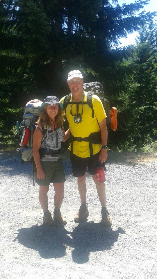
Packed up and ready!

With the car locked and packs filled, we hit the trail. My research revealed that this is bear and cougar country. So, we both wore jingle bells on our wrists and used trekking poles, which made us very noisy to any hungry or motherly creatures out there! And merry makers to others.

Bear Bells

Bear bells highly suggested!

The trail lies on the northern (i.e. sunniest) side of the river. The forest here is amber-colored bark Ponderosa pine. If you’ve never been in a Ponderosa pine forest – I need to describe. Instead of tightly laced tree branches typical of Douglas fir forests – which are shady and therefore offer a cooling effect, Ponderosa pines are spread farther apart, with not nearly as many branches between trees touching. Hikes in Pondersoa forests are more vulnerable to hot sun. This one is no exception.

The valley slopes reached skyward immediately from the northern side of the trail. Soon,  the place became a convection oven! We had no relief from the sun or the broiler-like hillside next to us. But there was more. There was winter blowdown. Packs on, we climbed over or slithered under fallen trees.

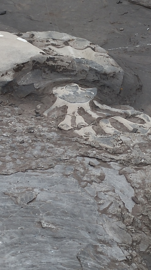
It didn’t take long for signs of large wildlife to appear. The recent rain and puddles left some flat, muddy areas. Anything walking over would leave footprints, betraying its presence. We noticed deer, elk, and then – bear and cougar prints!

Bear Track

No doubt about what left these prints!

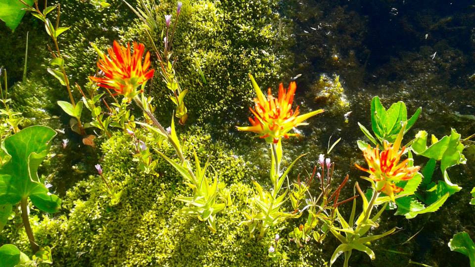
Not long after, and right smack in the middle of the trail, we saw a pile of poop. Not just any pile of poop. Because whatever this creature ate it was full of seeds! Bear scat. Between the trail and the river at this particular point is an area full of blackberries. No doubt this bear was feasting.

Heat aside, it’s a very beautiful river. It winds lazily along, and except for some deeper pools, it’s about 2-3 feet deep. But the heat quickly got to us. We found an open place for lunch and discovered it was a camping spot. It didn’t look like it had been used recently because growth was starting to cover the fire ring. As hard as it was to accept, we actually decided to base camp here. It was a place that offered shade!


Feeling guilty and pretty annoyed about the heat and the fact that we’d only covered 2.5 miles, we decided to hike further up the river. What we discovered unexpectedly justified stopping to camp were we did.

We didn’t find anywhere suitable to camp. And grass plus brush had assertively grown across the trail, about knee high. We wore shorts. And I’d heard stories about lots of ticks from other hikers recently. So we pressed on, but were constantly checking our legs for critters.

Eventually we’d had enough and, frustrated, we started back. Just when we began to get cranky, I saw a possible wading spot. We walked down there and waded out into the river. This was the respite we needed. More, we realized, this what this day was all about. Sitting in the river, with it flowing over our overheated souls, we cooled down enough and it became almost meditative. Impossible to get out.

Laura on rock in river

We spent time here, and then back at camp, spent more time just enjoying the water! Well, what to do with the rest of our time out here? We decided to get on the trail early the next day, before the heat picked up, hike out, and then drive over to Anthony Lakes and car camp.

Laura on Anthony Lake

An end-of-day happy hour at Anthony Lakes!

Anthony Lakes is a year-round recreational area. In summer there is camping, hiking, boating, and fishing. And even some sailing. It’s elevation is over 7,000 feet, so it’s got dry powder snow in the winter. The Anthony Lakes Ski Area is popular with locals all winter long. Plus, there are lovely Cross-Country trails all around. The stars were really spectacular. All together, we had a nice trip!


Backpacking to Mt. Jefferson and Jefferson Park

3 09 2015
Jefferson Park,Mt Jefferson,backpacking oregon,hiking oregon

Russell Lake – Mt Jefferson fills the sky!

One of Oregon’s wonders is Jefferson Park, and Laura and I recently hiked the Whitewater Ridge Trail to spend a couple of Eden-like days in its splendor!

A dormant 10,495ft high volcano, Mt. Jefferson is Oregon’s 2nd highest peak. It sports five glaciers. And sitting just below its northeast side is Jefferson Park – a square mile plateau sprinkled with wildflower meadows and brilliant lakes.

Laura and I backpacked about six miles up 1,800 vertical feet up the Whitewater Ridge Trail to reach it. The day we hiked, it was 85 degrees at the trailhead. Much of the route is exposed to the sun – with beautiful views, but on our day the heat and effort were what dominated our trip up.

Rod Richards,backpacking oregon,hiking oregon,jefferson park,mt jefferson

Now we just need to find a campsite!

But once at Jefferson Park any suffering we endured melted away amongst the sheer majesty of the place. Because once you have arrived, every view is dominated by Mother Nature’s spectacle. Look one way and the mountain covers the sky 180 degrees. Look everywhere and you see carpets of green, plus wildflowers and twinkling lakes. The biggest lakes are Russell, Scout and Bays, then there are smaller ones like Park Lake or Rockpile Lake

bays lake,mt jefferson,jefferson park

Bays Lake – Dive Right In!

Jefferson Park is a protected area within the Mt Jefferson Wilderness, and there are maybe two dozen designated campsites throughout. It’s very popular so some of it has been marked off limits for the land to recover. It’s all alpine flora, which is super delicate.

We’re trying to find my old favorite spot on Bays Lake. But it’s occupied, so we opt for a spot on Scout Lake. We’ve got nothing to complain about with our view.

Laura enjoying the warm sun

Laura enjoying the warm sun

And Laura has no problems settling into the routine. Before long she’s relaxing reading a book on Tibetan Buddhism in the fading afternoon sun.

We take a bit of time to explore the plateau. We head north up to the Russell Lake area. It’s a ways but worth the effort. We decide to return there the following day. There are not many wildflowers as times I have been here before, because in 2015 we have a severe drought. The wildflower season came very early. But on the other hand, huckleberries are everywhere! We collect huckleberries for breakfast.

huckleberries

These will be good at breakfast!

Then it was back to camp for dinner. I brought a quick fix rice side and blended it with cooked chicken. It looked huge but I ate all of it. Laura had simple cheese, crackers and some meat like sausage.

It was a beautiful evening. Starry and windless. I slept very well.

I awoke to a rosy dawn, and made hot water for coffee or tea. Those huckleberries went well with my oats and yogurt.

scout lake,jefferson park,mt jefferson,backpacking oregon

Our campsite view on Scout Lake

Hunger satisfied, we headed out for an exploratory hike checking out the area, and the first destination was Russell Lake. It’s about a mile north from our camp at Scout Lake, a completely flat trail meandering along the meadows, passing through islands of trees. We could see that a few weeks earlier it was a carpet of wildflowers everywhere.

Once we reached Russell Lake, we took a trail around the lake. We encountered campers, everyone gushing about how beautiful this place is. It was on the northern fringe of the lake where we found a micro-zone ecosystem with a view to knock our socks off.

The stream into Russell Lake

The stream into Russell Lake

There, a three-foot-wide stream meanders across the meadow before entering Russell Lake. It wets the soil enough to allow wildflowers to continue blooming along its path. And in the stream, we glimpsed frogs and minnows.

There was Indian Paintbrush, Lupine and several other species of wildflowers I couldn’t identify.

We spent a half hour taking pictures and examining this micro eco system.

Russell Lake Indian PaintbrushIt was so profound that just a bit of extra moisture kept this area lush with life, with an extended season, long after other parts of the meadows had gone to seed.

Russell Lake Stream3

Later, we headed over to Bays Lake for a swim. Bays lake has lots of boulders and it’s deep. We dove in and swam across, back and forth, revelling in the warm water and the beauty! We both decided to bring more friends up here in the future. It’s too beatiful and it’s got to be shared!

Following the evening meal another rock solid sleep.

The following morning, it was time to head out. The trail now would be all down, much faster and easier. We passed by several groups, pretty diverse! Some retirees, and I swear a lady over 80. And three kids, followed 5-minutes later by mom toting an Everest expedition sized 70 pound pack for all of them! Cheers for her!

Well, here is a victory photo. A trip well done! We’ll be back.

Rod Laura trails end portrait