MSR’s Hubba Hubba NX Tent – Review

15 03 2015
msr hubba hubba nx,gear shed,camping,camping oregon

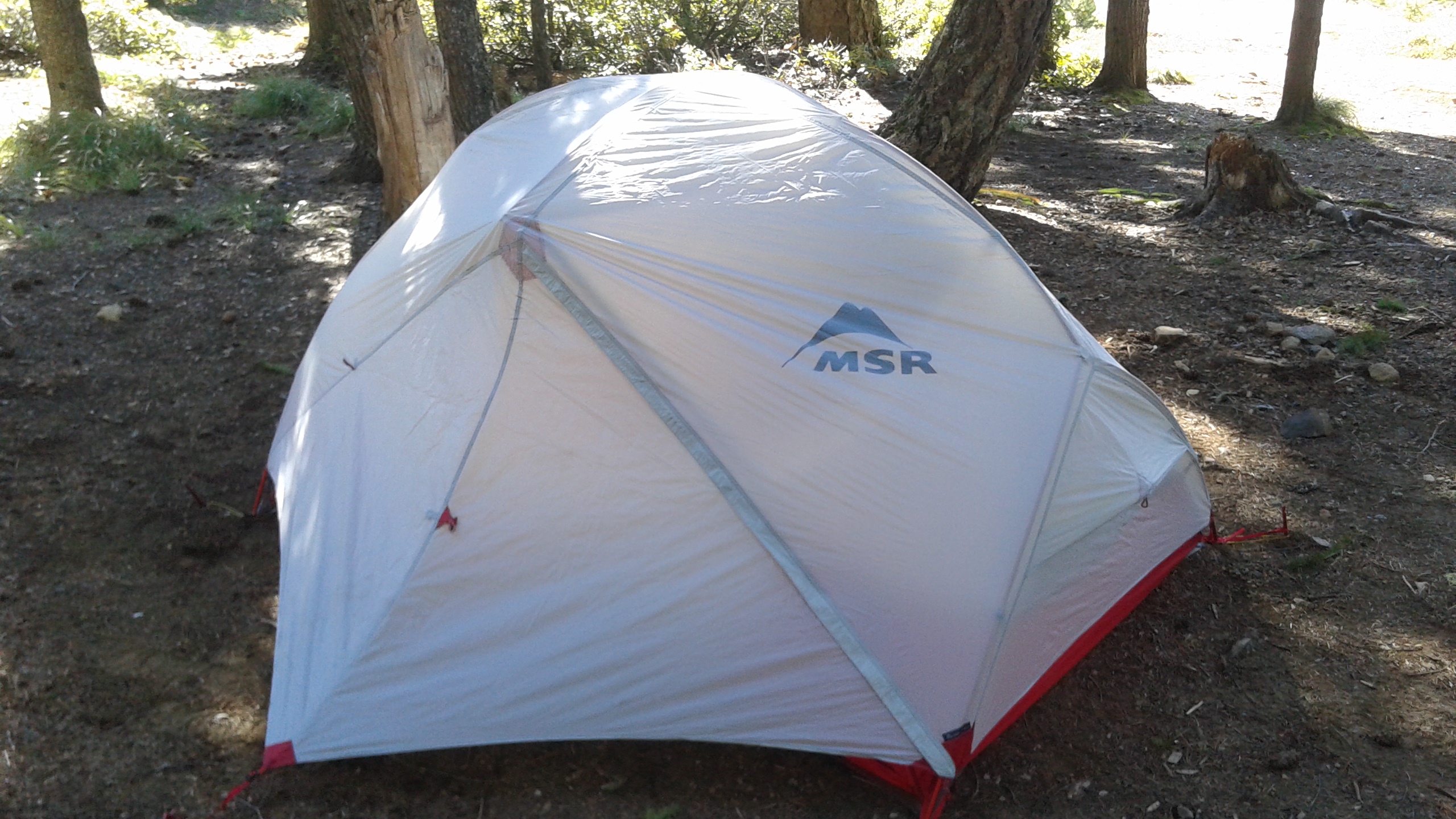
The Hubba Hubba NX with the Gear Shed

I’m the proud owner of a brand new Mountain Safety Research – MSR Hubba Hubba NX ultralightweight backpacking tent! With 27-year-low snowpack in Oregon’s Cascade Mountains, I couldn’t wait to try out my new tent. I also bought the “Gear Shed” attachment for the tent. So, I headed up to Clear Lake near Mount Hood, Oregon to set up and sleep in my new tent.

The MSR Hubba Hubba NX is a super light two-person tent – only 3.7 pounds! But any tent I’m going to be pleased using has to be easy to set up and durable. And on warm summer nights I like to set up the tent without the fly. This allows for star gazing and cooler sleeping. But some tents have a very shallow “bathtub” around the bottom, allowing breezes to get through, and onlookers to see you when you’re dressing. I like tents where the “bathtub” is a bit higher.

As a backpacker and kayak camper, I also want a tent that’s easy to set up in the dark. No complicated setups. I also like tents with reflectors so at night I can shine a light on them and see it from far away. Gear vestibules are also super important. I want my shoes and gear to stay dry even if it’s outside my mosquito-lined sleeping area. For windy days tents need to be guyed out. There must be ways to secure the tent to the ground, so it doesn’t blow away.

So with these needs / wants in mind I set about testing and setting up the MSR Hubba Hubba NX. Unpacking it from the bag, I immediately noticed thoughtful touches. The bag kind of cinches up like a cradle. The bag has outside straps enabling it to be scrunched down like a compression sack.

I set out the tent footprint and then laid the tent on top of it. I staked out the corners. Right away I noticed a clever detail where the attachment of the tent to the stakes takes place. A sturdy cinchable strap-to-stake attachment point. Nice!

msr hubba hubba nx

The tent pole goes thu this grommet. But you can tighten the strap to the stake. Thoughtful!

I unpacked the tent frame. On the MSR Hubba Hubba NX there is only one frameset where all the pieces are connected via shock cord. It’s made of DAC Pressfit aluminum. Light and durable. But you need to be careful and deliberate about connecting. I fear splitting a pole end if I am in a hurry.

msr hubba hubba nxI laid the frame on top of the staked-out tent.

The next step is to connect all four corners and the top center piece to the frame. It’s a little challenging do do alone but with practice it will be easy.

msr hubba hubba nx

Frame connected and ready for clips

OK. So now, the next step will be snapping the clips to the frame.

It’s here I notice another thoughtful and durable touch.

The clips are shaped to fit snugly around the poles, but there is more. The load of the clip is spread between two attachment points on the tent. This reduces stress points on the stitching on the tent.

msr hubba hubba nxSo far, I’m delighted with the thoughtful, clever details of this tent. And all for 3.7 pounds! Next step is to connect the clips. Once done I’ll have the full volume of the inside.

msr hubba hubba nxThis is how nights under the stars will be. This is how I like things – there is a good view of the sky above, and ample ventilation – but the bathtub walls are high enough to shield occupants from wind and from onlookers.

Next, the fly. A fly should be able to keep rain out but also allow for ventilation – and especially bonus points are awarded for flies that can be unzipped without rain dripping into the tent.

msr hubba hubba nxVoila. with the fly attached, and the vestibules stakes out, there is actually a lot of acreage to store packs and shoes out of rain’s way. Two tent mates each have a vestibule and exit for themselves. Inside the tent, on each end, there are tent-wide gear pockets. Enough for most any backpacker’s needs. Up above, there are attachment points so you can sling strings – from which you can dry your stanky socks. Unfortunately two things are lacking – Firstly, a distinct shortage of attachment points for guy lines and secondly, no reflective piping.

But let’s say you have need for even more room. You have a disagreement with your tent mate. Or perhaps there is a 3rd soul needing a place to rest for the night. Or you’re car camping with executive camping gear and you’re needing extra storage space. For that, the MSR Hubba Hubba NX offers a solution: The Gear Shed.

The Gear Shed doubles the available storage space. Or can be used to accommodate another camper – or a Man’s Best Friend? If you have the MSR Gear Shed, you have options.

20150312_153922What’s the verdict? Well, although I love this tent and gear shed setup, it’s not 100% perfect. Somehow designers left out reflective materials. At night I bumped the corners more than once. And I have to wonder about its ability to hold up in the wind without lots of guy line attachment points. Still, I love the MSR Hubba Hubba NX and it’s a keeper. I can recommend it!


I Love Camping and Hiking in the Metolius River Region

7 01 2015
metolius river,camping in oregon,camp sherman,camping camp sherman,trout fishing oregon,allen springs campground

The Metolius River from our campsite!

Bubbling up from the ground fully-formed, the Metolius River, at Camp Sherman, Oregon, is one of the state’s most magical outdoor gems. The Metolius River Valley stretches 13 miles from the mouth. Because it lies just to the east of Santiam Pass, it is solidly in the Central Oregon ecosystem. Blessed in a rain shadow, the valley is dry most of the year – and dry-climate-friendly Ponderosa Pines dominate the forest.

There is a lot going on in the Metolius River Valley – but it’s subtle. It’s not widely advertised. First and foremost, it’s all about the river. At the head of the valley the Metolius emerges from the ground as a fully formed river. It’s not a little spring. It is urgently rushing out at its headwaters. The water is glacier snow melt coming directly from glaciers in the Three Sisters, where it disappears underground and flows for many miles in underground lava tubes, only to emerge in the Metolius River Valley. That means it’s extremely cold and pure.

metolius river,camp sherman,fly fishing,metolius river fishing,camping in oregon

Fly fisherman on the Metolius

This river, wending its way through snags and bends, is perfect habitat for trout and salmon. The Metolius River is a national blue ribbon trout fishing stream. When visiting the area you always glimpse fly fishermen trying their luck along its banks.

metolius river,allen springs campground,camping in oregon,camp sherman

Nothing like a multistory fire!

There are several campgrounds sprinkled along the Metolius River, plus there are lodging opportunities in Camp Sherman. My personal favorite is Allen Springs Campground because it sits along a U-shaped bend in the river. There are three walk-in campsites on the U-shaped peninsula. If you score the campsite at the end of the peninsula, you have guaranteed privacy and simulated back country camping. You just need to walk your gear to it. This guarantees no RVs parked next door. No generators grumbling during the night. All you hear is the glorious burbling of the Metolius!

Forget to bring everything? Fear not. You can get what you need at the Camp Sherman General Store. Even better, the store has delectable made to order sandwiches! It’s worth not bothering to pack your lunch because you can get a scrumptious fresh hand made sandwich at the store! If you order a club sandwich they’ll be cooking the bacon right in front of you.

There’s much more. There is a hiking trail running for at least 10 miles – down one side of the river and back up the other. A visit to the Wizard Falls Fish Hatchery is well worth the stopover. For swimming and boating, Suttle Lake is just a few miles west of the exit for Camp Sherman off the highway. And in July, if you are up for an alpine hike through spectacular wildflowers, Three Finger Jack beckons.

rod richards,roderick richards,three fingered jack,hiking oregon

Rod pauses in front of Three Fingered Jack

On this trip my old college buddy Tully accompanied. For dinner, we used the tried-and-true Wok cooking method. Wokking is a great alternative to traditional camping meals. First and foremost it’s delicious! And fresh. It’s great for group cooking because the ingredients are all laid out and then each camper cooks their own. Some may be intimidated at first, but it’s virtually impossible to screw up a Wok meal!

wok cooking,camp cooking

But prior to dinner there is the obligatory post-hike and pre-dinner happy hour. That requires a campfire. We violated all dietary guidelines by having a bag of Fritos. A camping secret is that Fritos and Doritos are excellent fire starters!

fritos, frito-lay,fritos fire starters

Fritos are super fire starters!

No kindling??? No problem, IF you have a bag of Frito-Lay products on hand. The next thing is music. Tully provided plenty of songs from The Grateful Dead, The Eagles, and Eric Clapton. All good blended with the burbling of the Metolius River.

metolius river,allen springs campground,camp sherman,camping in oregon

Tully pickin’ on the guitar

Next day we glimpsed an unusual sight walking along the river. Turkeys!

turkeys in oregon,turkeys,camping in oregon,camp sherman,metolius river

Turkeys!

There were 8 – 10 of them. Who knew! During a lunchtime visit to Camp Sherman we learned there are a lot of turkeys in the valley and they are a nuisance to some homeowners! The ones we saw looked innocent enough.

If you are in Central Oregon you should consider a visit to the Metolius Region!


North Fork John Day River and Granite Oregon – Gold Country!

31 10 2014

north fork john day river, camping, oregon, hikingHiking on the North Fork John Day River Wilderness Trail has been on my bucket list. So I made plans with my friend Tully to head out there and explore the river, and to check out the central northeast Oregon area – also known for its place as Oregon’s Gold Rush region.

The North Fork John Day River is a National Wild and Scenic River for good reason. It’s remote, it’s to-die-for beautiful, and it’s got historical gold miner’s cabins sprinkled along the way. One can do out and back hikes, or circular routes, or even through hikes where one car sits at the beginning and the other at the end.

An ideal spot for exploring the area is the North Fork John Day Campground. It’s on Forest Service Road 52 and is right at the intersection of the Elkhorn Scenic Byway and the Blue Mountain Scenic Byway.

When we arrived, there were only three campsites occupied of the twenty available. Instead of camping at a drive-in site, we picked a walk in site right on the river. It had plenty of real estate and we couldn’t see anyone from the site. Our first dinner was a skewer bbq – chicken with veggies on skewers and some rice.

Next morning it was time to hike the trail by the river. The trail wends its way sometimes right along the river and often climbing 100ft above. But always it’s really beautiful.

north fork john day river, columbine, wildflowers

Columbine

indian paintbrush

Indian Paintbrush

We saw a lot of wildflowers along the way.

Lupine, Indian Paintbrush, Columbine, and others I can’t positively identify.

There were popcorn clouds, so the lighting in the river valley varied as we walked along.

The breeze was refreshing.

We came upon some strange things in the trail. It looked like hair. Lots and lots of hair. Or fur. Light brown fur. But no skin. What could it mean ? And then, not long after, we saw the remains of a large animal down upon the bank of the river.

DSCF1577 Was it a horse? Or an elk? Its head was nowhere to be seen. What killed it? It might have been a cougar. Hunting season was back in the fall.

In any event, the carcass had been picked clean. Nothing left but bleached bones.

So along the trail we walked. Further down the river we glimpsed some history we’d heard about.

This region, which includes the towns of Sumpter, Bourne, Greenhorn and Granite, was a Gold Rush area in the late 1800’s and even into the early 1900’s. Even today, there are claims along some of the creeks.

The first thing we encountered was a miner’s cabin. It looked like it had just been abandoned.

DSCF1573DSCF1575There was still some structure to it. It even had a kitchen counter and rusty remains of beds.

I sure wouldn’t want to stay in it!

One has to wonder what was going through the minds of the people that built these places.

The windows definitely were not from 1890. They looked like they were 1970’s vintage.

It must have been a rat and bug infested sleeping experience for sure.

The place had an outhouse not too distant. Peering into that structure gave me the creeps, as if Hannibal Lechter from “The Silence of the Lambs” lurked somewhere down below.

DSCF1566The North Fork John Day River Trail is a beautiful experience. I did not backpack it this time – as Tully doesn’t backpack. But I will return here and do a backpack for sure. It’s got to be the best way to experience the area.

The following day we decided to drive out to Granite, Sumpter and even Bourne. This is the heart of Oregon’s Gold Rush Territory.

Leaving the campground, Granite, Oregon is only seven miles away. It has a population less than 50 and struggles to survive as a recognized town. But it does have a gas station and a store. Only not open when we were there! Interestingly it has a free Internet wireless antennae right in the midst of the 30 or so homes littering thee hill it lies on.

We drove on to Sumpter, Oregon. There are countless mining claims lining the road. We never saw an

ybody mining but there were hundreds of piles of “tailings” where people had piled rocks and sand in their efforts to find the gold.

IMG_1073

On the way we decided to explore a dot on the map called Bourne. Driving up its little side valley, one wends through countless 15-ft high piles of tailings from past mining endeavors. Almost when you think it’s time to turn back, you find Bourne. Sitting at the end of the road, in a valley, are maybe two dozen homes some of which have actual mine shafts on their property.

Not much going on there these days. We got out of there pretty quick.

After Sumpter we decided to head over to Anthony Lakes, on the other side of the Elkhorns. The road climbs to 7,450 feet before descending to the lakes. The Anthony Lakes Ski Area was long closed for the season, but I just had to drive my car up to the ski lift to see if I could catch a ride!

All in all we had a good trip up there. It’s quiet, remote and there’s quite a bit to see if you make the effort! You will not find Disneyland crowds for sure.

anthony lakes ski area

IMG_1072


Waldo Lake Oregon – Water Doesn’t Get Any Purer Than This!

26 09 2014
paddling,waldo lake,oregon,camping,kayaking oregon

Paddling over the indigo waters on a calm morning.


There are a lot of breathtaking places to paddle in Oregon. Many places with jaw dropping views. But only one, Waldo Lake Oregon, has such pure water and easy back country kayak camping – with no power boats to interfere with the serene experience!

Waldo Lake is unique in Oregon. It’s 22-miles around, making it the 2nd largest natural freshwater lake in the state. It’s natural – not a reservoir. It’s high elevation – 5,414ft. No power boats. Just human powered craft, like canoes, kayaks, or row boats, and when the wind picks up – you’ll see sailboats plying its waters. The water is so pure Waldo Lake set the world’s deepest visibility record – you can see down 157-ft! It is almost as pure as distilled water.

I organized a group of 12 friends (and Cameron, a 3-year old happy camper) who convened at Waldo this past weekend. Waldo is renowned for its primitive camp spots on the west side of the lake. But this weekend, dry conditions caused the Forest Service to issue a ban on campfires outside established campgrounds.


kayaking waldo lake,kayaking oregon,camping waldo lake,camping oregon

Katie, Christian and Cameron

We needed a fire to cook a salmon for six – because my friend Daniel Fox, who was paddling from Victoria BC to San Francisco, had stopped in Astoria, Oregon and just caught a nice Chinook salmon on the way! It had to be cooked on the fire. So, we settled on camping at North Waldo Campground. It was almost full when we showed up – only three campsites – and we needed all three! It was totally last minute. We all had packed compactly for wilderness camping. Once the car camping decision was made I pulled out everything. The barbeque, the tiki torches, the tablecloth!

north waldo campground,waldo lake,camping,hiking,oregon,kayaking,canoeing

Happy hour watching sunset!

The salmon turned out delicious and there was plenty for all. Simple – cooked in olive oil wrapped in tin foil and some dill added. On the side were veggies cooked in tin foil. Really yummy!


camping oregon,camping waldo lake,waldo lake,north waldo campground

Folks at site #32! Waldo Lake awaits.

Morning all awoke at a different pace. At campsite we were up by 7:00 and ready go to by 9:00 – but a visit over to George & Kristi’s site revealed they’d just awakened when I got there at 9:30.

My breakfast was just oats, berries and yogurt…Kristi’s was more like home! Either way breakfast in the woods is better than at home!north waldo campground,waldo lake camping For me, anyway.


View west with kayaksIt was time to set out on the lake. There is much to explore. There is “the burn” on the north side, full of coves and warmer water.On the west side there are primitive camping sites for miles. There is a trail to a lookout, up 2,000ft, where views of Central Oregon can be glimpsed. And halfway down the west side of Waldo Lake, Rhododendron Island. It’s a good spot to land your craft for a picnic!

The water of Waldo Lake is “dramatically ultra oligotrophic” meaning crazy clear with little organic matter. Chemically speaking, it’s more pure than distilled water. At an elevation of 5,414 feet, it’s so high it has no incoming streams. The water comes from snowmelt or springs. As such it’s so pure that a food chain is not supported. We saw only four seagulls and certainly no ospreys.

Words cannot really describe the clarity or color of Waldo Lake’s waters!

dramatically ultra oligotropic,waldo lake

Shadow, some 60 feet down. In deeper water the blue darkens.

Out in the middle of the lake, the water can appear purple-indigo. Look up ultramarine blue.

I took a photo of myself from under the water.Rod from underwater - Copy

We experimented with taking underwater photos from all sorts of angles.


kayaking waldo lake,paddling oregon,camping oregonOne such photo was taken by Bill Baxter from underneath his kayak! It makes the surface kind of look like blue mercury!

It was a glorious day! Our group split up. Some, led by April, set out to kayak to a trailhead and climb some 2,000 feet to an abandoned fire lookout. From there you can see the lake plus all of the Central Cascades Region of Oregon including Diamond Peak, the Three Sisters Wilderness, and Bend.

The rest of us paddled south to have a picnic at Rhododendron Island. On the wind protected side of the island it was HOT!


waldo lake,oregon, waldo lake snorkeling

Bill shows Cameron a frog!

After lunch we dared the chilly waters. Bill seemed less concerned than most and was out there with mask and camera quickly.

waldo lake water,waldo lake,oregon

You can see across as well as down


It took me forever to finally get all the way in the water. I should have just dove in!

Julie’s thermometer said it was 66 degrees. That is not terribly cold!Half Underwater

We all got together for a Mexican “bar” meal back at the campsite. It was a make-your-own burrito affair.

We set out the ingredients, then one would wrap up in aluminum foil & melt/heat over the fire!

Katie gets Cameron ready for the water

Katie gets Cameron ready for the water

It was a good reward after the hikes, paddling and picture taking!

We all agreed we will come back next year.

NOTE!! Waldo Lake is full of biting bugs/mosquitoes until mid August.

Plan your trip for late August or September. We think the best way to experience Waldo Lake is to camp outside the established campgrounds on the west side of the lake. There are plenty of gorgeous sites. But if your preference is for car camping, we recommend making a reservation – we managed to get the last three sites! Waldo Lake is unusual in that it gets more busy after Labor Day – and that’s because everybody’s avoiding the mosquitoes.


Timothy Lake, Oregon – Leading A Horse to Water!

13 09 2013

IMG_0711  This is a quick blog post about a trip to Timothy Lake, Oregon, which I took before my Eastern Oregon byways trip (see last blog). Timothy Lake is 13 miles south of Mount Hood. It’s an easy 1:20 drive from my home. So, if I want to get outside but don’t have a big window of time, sometimes I head up there. If you read my last blog post, you know that I suffered a back injury a couple of weeks prior to this week. Well, it turned out that on this trip, sleeping on hard ground was great. I slept like a baby. I actually slept better than in my own bed. But a week later, at Anthony Lake, everything changed.

IMG_0714

Trees in Oregon grow really tall…!

This post is about happier times. With only a couple of days in the middle of the week free, I hurriedly packed my car and headed up to Timothy Lake. With my back trouble, I left the kayak at home. I found a west facing camping spot – with nice trees above.

I set up camp and then hiked down the lake two campgrounds distant. It was such a pretty day, and my body enjoyed the easy exercise.

Along the way I encountered a family with horses. They did something completely unexpected. They started leading the horses into the water!

IMG_0707

Mom, daughter and horses. All somehow cooperating!

IMG_0710

Daughter learns you can lead a horse to water, but…you can’t…


It was so endearing. These big animals, who could cause harm, totally cooperated with the human tenders…even kids. The adults rode them into the lake, and the kids guided them out.

Horses are so gentle. It was something to see! I was sure the horses weren’t comfortable out there in the lake. Yet, they trusted their owners – enough so that they even went beyond standing – even swimming!

I thought that was pretty cool. Then I returned to my campsite. It was a quick walk down to the water, and I enjoyed the sunset with a magazine and a pint of beer.

Then it was time to make a fire, and I had a lot of wood.

IMG_0713I made a “log cabin” style fire, which went up big. Very nice. Following, it was time for dinner. I brought up some freshly made tortellinis, which were easy and delicious. Plus a nice green salad.

Then crawling into my tent, I managed to have a super restful sleep. I had no idea one week later camping would turn out to be so painful.

Till next time!

It is September. This month is usually the best month for enjoying the outdoors. No bugs. Good weather. Crowds – gone after Labor Day. But sadly, my ability to get outdoors is hindered by my back and hip injuries. I am confined to the city, and I am following docs orders and trying to get out before the weather turns!

Wish me luck.


Oregon’s Gold Rush Region! Sumpter, Oregon and Granite, Oregon

6 09 2013

Route MapMy interest on this trip was focused on the areas around the North Fork John Day River Wilderness Area. I’d be driving Oregon’s Route 7, Route 73, Route 20 and Route 52. Today, I’d pass through Prairie City – on state highway 26, on my way to Sumpter, Oregon. This is 100% marked as scenic on the maps!

I’d be camping at Anthony Lake, though I didn’t know it when I began. I will tell you the drive along Oregon’s Highway 26, the Journey Thru Time Oregon Scenic Byway, is serene and calming. It wends its way through ranches and farms and small towns like Mitchell and Dayville, with less than 250 population. Absolutely nobody is in a rush here.

A few dozen miles east lies Prairie City. They’re making an effort to refresh main street here, and it looks pretty. I fill the tank with gas, and here they still clean your windshield! Then Oregon Route 7 intersects, and I’m on my way up to the Elkhorn Mountains, climbing all the way.

This is GOLD RUSH territory! In 1883 Sumpter was founded. By 1897 a railway reached the area, and the population grew to 2,000 as gold mines and claims proliferated. There were 12 miles of underground tunnels. Even today, I saw staked out gold mining claims!

Fort SumpterThese days Sumpter is preserved as a tourist attraction of Gold Rush history. Much of it has been restored to look as it was. I even saw a fort. I wondered if that fort was supposed to look like the Civil War Fort Sumpter? To me, it looked like it was right out of the 1960s TV series “F-Troop.”

Two of Sumpter’s main attractions are the Sumpter Valley Railway and Sumpter Valley Dredge. The railway, opening in 1890, was built to haul lumber 22 miles to Baker City. Within two years it was hauling passengers and freight. Today, it is a 6-mile narrow gauge tourist ride.

The Sumpter Valley Dredge is a monument to capitalism and 19th century technology. These 4-stories-tall dredges floated in ponds, and as they dug, the ponds moved with them. They consisted of conveyor belt of buckets to dig earth and carry inside for processing, the internal processing machinery, and another conveyor out back to dump out the waste. There were three of them in the valley. Ironically even though they only employed three workers each, they ended their machine-lives $100,000 in debt. Sumpter Dredge

Climbing out of Sumpter, the road switchbacks ever higher. I drive along a high altitude creek lined with mining claims, and with piles of rocks which could only have been left by days-gone-by gold prospectors.

Then I reach Granite, elevation 4,695. Granite’s population is 38. It looks bigger than that. It’s got a “Welcome to Granite” sign over the road. It’s got a fuel depot and a hotel. Still, it has a look and feel of a genuine frontier town. Founded in the 1880’s, granite boasted a population of 86 gold miners by 1940, but in WWII, the government ordered gold mining shut down to make miners dig for “esseFire Crew Signntial war effort” materials. Granite collapsed, and never recovered.

Past Granite, I made up my mind that I would camp at Anthony Lake, some 40 miles distant. I’d be cruising the Elkhorn Oregon Scenic Byway. On my way to that byway I ran across something unsettling – a Forest Fire Camp. During this trip there was a giant fire threatening Yosemite National Park, so forest fires were in the news.

Yet I didn’t know that the Forest Service established camps supporting hundreds of firefighters even before a fire started. Wow. That is serious.

Fire Crew StationThe camp I saw was several acres, high in the mountains, in a big meadow. And as big as it was it was clear that there was room for probably a thousand men up there.


Fire Crew2That made me much more aware of the gravity of the situation.

Beyond the Fire Camp, I ran into something I came out here for. It is the trailhead for the backpacking trail on the North Fork of the John Day River. I had heard about this many years before and now I was here. Too bad I am injured now, and can’t do it. But I will be back.

NF John Day SignIt’s very very pretty up here, and there are just not a lot of people to bother you. That is the beauty!

I decide to push east and camp at Anthony Lake. I have been there to ski in the winter, but never seen it without snow. I just have to check it out. On the way I reach a high point in the Elkhorn Moountains, about 7,250ft.Elkhorns 7250

The view goes on forever. It seems a high plateau goes on from here and one could backpack quite a ways.

Then I descend down into the Anthony Lakes area.

The lake is much smaller than I remembered, as I had cross country skied around it two times in the past.

Anthony Lake PanoramaI had imagined it would have campsites on it. But nope. The campground is to one side, and it has day use areas on the other. There are walk-in sites to another side.

I also paid a visit to Anthony Lakes Ski Area.Anthony Lakes Sign


Without snow, it looks so different. I quickly realized I could actually drive around the lodge and onto some of the lower slopes I had skied!

This was pure devilish fun! Well, with that bucket list item checked off, I returned to the campground and made my meal. I grilled a pork chop, made mashed potatoes, had an awesome campfire, and salad. Then, off to sleep.

I had hoped to see a million stars – but that was not to be. The smoke from the Yosemite fire partially obscured a picture perfect view. Next time I guess!


xx